Our system will evaluate the answer based on this AI-generated description.
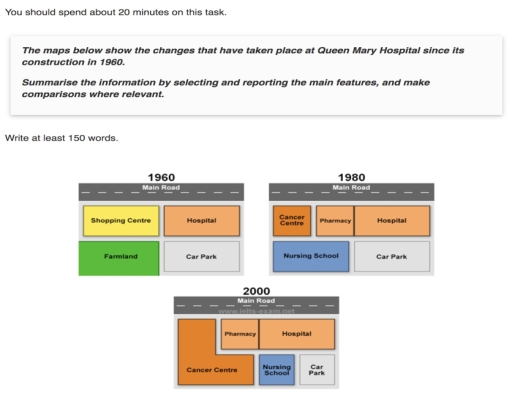
The image presents three maps illustrating changes at Queen Mary Hospital from 1960, 1980, and 2000. In 1960, the hospital's layout included the main hospital building flanked by a shopping center to its left and a car park and farmland to the right, separated by a main road running horizontally across the map. By 1980, the farmland was replaced with a nursing school adjacent to the expanded hospital sector, which now also included a cancer center and a pharmacy. The layout retains the shopping center on the left but replaces the original car park with a new one on the right. In 2000, the map shows further expansion: the shopping center and farmland are removed entirely, making way for additional hospital-associated facilities including a larger cancer center, a more prominent nursing school, and an established pharmacy; the hospital remains central. The car park's location persists on the right side of the map. All maps maintain the main road as a consistent horizontal divider through the years.
Given the complexity of the image, the above description may not be entirely accurate.
Skyrocket your IELTS band score by 1-2 points in under a month with our premium plan!
Note: Both the topic and the answer were created by one of our users.
The 3 maps illustrates the development changes that occured at Queen Marry Hospital in 3 different years, that is 1960, 1980 and 2000.
Overall, it is noticable that when the first construction was done in 1990 there was additional departments were added to the building with the expansion of building. In the latest development happend in 2000, one of the section was expanded while some of them remained same.
In 1960, the area was equally occupied for hospital, shopping centre, farmland and for car parking. After the first reconstruction was done in 1990, the shoppoing centre was replaced by dedicated sapce for pharmacy and cancer centre. In the place of farmland school for nursing was built. However, the car parking and hospital area was unchanged.
In the latest map of 2000, the cancer centre was expanded, hence the area for conduction lectures for nusring students with the car parking area was constricted. Again in 2020 the space occupied by hospital and pharmacy was the same as in 1990.
Word Count: 168