Our system will evaluate the answer based on this AI-generated description.
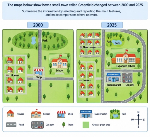
The image presents two town layout maps labeled "2000" and "2025", accompanied by a bottom legend and a compass rose indicating north ("N"), south ("S"), east ("E"), and west ("W"). The legend identifies symbols for "Houses", "School", "Shop", "Supermarket", "Park", "Road", "Car park", "Trees", and "Grass / green area". In the "2000" map, a main road runs north–south with a perpendicular road extending west and east; the northwest and northeast feature a large "Park" with trees and a pond; the southwest contains 8 "Houses" on side streets; a "Shop" sits at the central intersection; a "School" is situated east of the main road; and scattered trees occupy the southeast grass area. In the "2025" map, the main road connects to a loop road curving around the eastern perimeter; the northwest area contains 7 "New houses"; the southwest area retains 8 "Houses"; the central-east area features a "Supermarket" and an adjacent "Car park"; the school is replaced by a larger "Expanded school"; a smaller "Park" containing a pond and trees is relocated north of the school; and the southeast area remains green space with scattered trees.
Given the complexity of the image, the above description may not be entirely accurate.
Skyrocket your IELTS band score by 1-2 points in under a month with our premium plan!
Note: Both the topic and the answer were created by one of our users.
The given map illustrates the information on the data on how a small town called Greenfield changed between 2000 and 2025.
In general, the Greenfield town underwent significant changes, turning from rural area to a more urban one.
In 2000 there used to be an empty field in southeastern part of the map,which became car park and supermarket in 2025.On the other hand,the former forest in northwestern part of the map was converted into new houses area. In contrast,old houses area and the central road remained unchanged. In northeastern part of the map the school was expanded while the lake was transported from the western part to eastern part of the forest. In 2000 there was a small shop in the central part of the map witch was demalished in 2025.
The roat between school and supermarket was shortened while a new road was built around the eastern part of the map.
Word Count: 152
