Our system will evaluate the answer based on this AI-generated description.
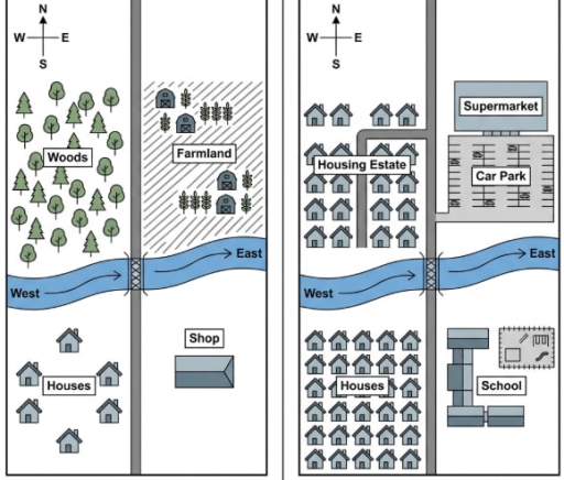
The image displays two comparative maps divided by a central border, both featuring a four-point compass rose (N, S, E, W) at the top left, a vertical north-south road crossing a horizontal river flowing from "West" to "East" via a central bridge. In the left map, the northwest quadrant is labeled "Woods" with numerous tree icons; the northeast quadrant is labeled "Farmland" with diagonal hatching, 4 barn icons, and wheat symbols; the southwest quadrant contains 5 house icons surrounding the label "Houses"; and the southeast quadrant features a single building labeled "Shop". In the right map, the northwest quadrant features a side road off the main road forming a "Housing Estate" containing 16 house icons; the northeast quadrant contains a side road branching to a rectangular "Car Park" situated south of a building labeled "Supermarket"; the southwest quadrant contains an expanded grid of 29 house icons centered around the label "Houses"; and the southeast quadrant features a multi-section building complex and an adjoining fenced outdoor recreational area labeled "School".
Given the complexity of the image, the above description may not be entirely accurate.
Skyrocket your IELTS band score by 1-2 points in under a month with our premium plan!
Note: Both the topic and the answer were created by one of our users.
The map compares how the town of Kingsley changed between 1950 and now.
Overall, the town experienced substantial redevelopment, with the introduction of several facilities such as supermarket, car park and school. Moreover, despite the apparently significant changes, certain key elements, such as bridge and river remained unchanged.
In 1950, there was a farmland in the north east of the map and adjacent to the farmland the wooded area was situated. To the south side of the woods area there was a river running through the middle of the map from west to east. The small shop was located in the south-east of the map and beside it few houses were occupied. In the centre of the map the small bridge was placed.
Since then, the town underwent several changes. The wooded area was demolished and replaced by housing estate and to the right side of the housing the farmland was destroyed to make way for a supermarket and car park. In the south-west of the map the houses were expanded with adding many homes and in close proximity to houses the small shop was partially removed and gave way to a larger school. Throughout these developments, the town maintained its essential amenites, such as river and bridge, which remained in their original locations.
Word Count: 214
