Our system will evaluate the answer based on this AI-generated description.
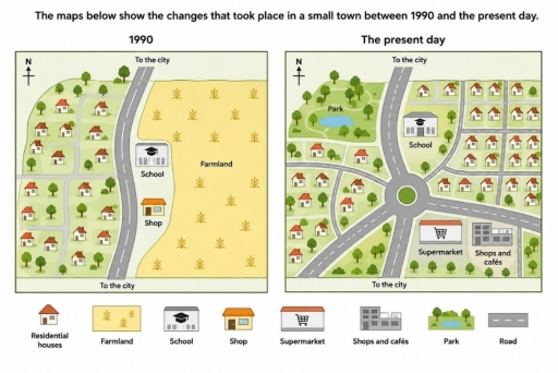
The image displays two comparative maps labeled "1990" and "The present day" accompanied by a bottom legend with 8 symbols: "Residential houses", "Farmland", "School", "Shop", "Supermarket", "Shops and cafés", "Park", and "Road". Both maps include a north directional arrow at the top-left and roads labeled "To the city" exiting to the north and south. In the 1990 map, a single two-lane road spans north-to-south; to its west lies a residential zone with side streets, scattered trees, and 13 residential houses; to its east sits an area with a "School" and a "Shop", alongside an extensive expanse of "Farmland" occupying the eastern half. In The present day map, a central roundabout joins five branching roads; the northwest quadrant features a "Park" containing a pond and trees; west and southwest sectors contain 12 residential houses; northeast of the roundabout sits the "School" alongside an expanded residential grid with 21 residential houses; and the southeast sector contains a "Supermarket" and "Shops and cafés" bordered by trees, with "Farmland" and the original individual "Shop" no longer present.
Given the complexity of the image, the above description may not be entirely accurate.
Skyrocket your IELTS band score by 1-2 points in under a month with our premium plan!
Note: Both the topic and the answer were created by one of our users.
The maps illustrate the transformation of a small town from 1990 to the present day.
Overall, the town underwent substantial redevelopment, with a noticeable expansion of residential and commercial facilities, alongside major improvements to its road network. These changes indicate that the town has evolved from a predominantly rural settlement into a more urbanised community.
In 1990, a main road ran through the town, connecting it to the city while dividing it into two distinct areas. To the west of the main road was a residential area surrounded by trees, whereas to the east of it were a shop and a school, both adjacent to extensive farmland.
At present, the main road has been widened and integrated into an improved road network, centred on a roundabout, which connects the surrounding roads. The original houses situated in the northwestern part of the town were demolished to make way for a park, while those in the southwestern area remained unchanged. Meanwhile, the school appears more modern, and the shop was replaced by a supermarket and a building comprising several shops and cafés. Much of the farmland gave way to residential and commercial areas.
Word Count: 191
