Our system will evaluate the answer based on this AI-generated description.
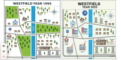
The image features two comparison maps titled "WESTFIELD YEAR 1995" and "WESTFIELD YEAR 2025", each containing a four-point directional compass rose labeled N, E, S, and W in the top-right corner, a north-south flowing water body labeled "RIVER", a network of gray roads, and a railway track bordering the western and southern edges. In "WESTFIELD YEAR 1995", west of the river features a railway track with "RAILWAY STATION" in the southwest, a parking sign ("P") with 2 houses, "HOSPITAL" centrally, "SCHOOL" northeast of the hospital, multiple scattered trees, a total of 6 residential houses, and two large designated green forest plots (one northwest, one south-central adjacent to the river). East of the river in 1995 features scattered trees, 4 houses, and 2 medium-rise buildings in the northeast; a large green forest plot in the east-central section; and in the south, scattered trees, 8 houses (arranged 4 over 4), a large brown building, an adjacent smaller building, and 2 multi-story tower blocks separated by trees at the bottom. In "WESTFIELD YEAR 2025", west of the river shows the railway track leading to "RAILWAY STATION", 2 smoking industrial facilities labeled "FACTORY" in the south, two multi-story structures labeled "OFFICE BUILDING" centrally, a "P" parking sign, "HOSPITAL", "SCHOOL", an airplane symbol enclosed in a blue circle in the north, 7 residential houses, and scattered trees. East of the river in 2025 contains scattered trees, 3 multi-story buildings, and 2 houses in the northeast; 8 houses in two rows of 4; retail facilities labeled "DEPARTMENT STORES" and "SUPERMARKET"; and 3 multi-story tower blocks interspersed with trees along the bottom edge.
Given the complexity of the image, the above description may not be entirely accurate.
Skyrocket your IELTS band score by 1-2 points in under a month with our premium plan!
Note: Both the topic and the answer were created by one of our users.
The maps illustrates the crucial changes in the landscape and the development that had taken place in the town , called Westfield, between 1995 and 2025.
Overall, it can be seen that Westfield had turned from a residential community into a thriving industrial town.
In 1995 , Westfield had very few facillities and structure .The landscape was mostly undeveloped with the number of trees and wide space in the town .The eastern side of river was the address area with accommodations such as houses and apartments .On the other side , to the west has some public facilities which are the school , the hospital and the railway stations, including houses , were located at that time .
By 2025 , there were significant changes in the town as the number of buildings and public structure increased . For instance, on the west side of the town , many factory, official building, railroad stations, hospital , airport and schools. However , on the east side , many houses were demolished and replaced with apartments block, a supermarket and big department stores , Another a remarkable development was the extension of a new railroad connecting both sides of the town.
Word Count: 199
