Our system will evaluate the answer based on this AI-generated description.
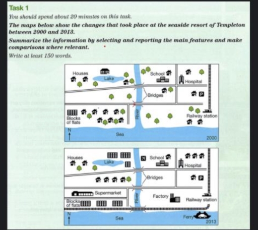
The image presents two comparative map diagrams labeled with years "2000" and "2013", both featuring a north arrow "N" at the lower-left, a southern coastline labeled "Sea", a central vertical "River" emptying into the Sea, two horizontal roads crossing the river via "Bridges", and various labeled infrastructure. In the "2000" map: west of the river features "Houses" (4 house icons and 3 tree icons around a central "Lake"), 2 tree icons between the roads, and "Blocks of flats" (1 block icon) adjacent to 7 house icons and 5 tree icons near the Sea; east of the river shows a "School" with 1 house and 2 trees, a "Hospital" with 1 house and 1 tree, a parking "P" area with 1 house, 1 house and 1 tree between the road bridges, 3 trees and 2 houses in the south, and a north-south track leading to a "Railway station". In the "2013" map: west of the river features "Houses" (2 house icons, 1 tree) west of "Lake", 3 flat block icons north-east of the lake, 4 house icons and 2 trees between the roads, a "Supermarket" building below the middle road, and "Blocks of flats" (3 block icons) along the south; east of the river features an airplane icon next to "School" with 1 house, "Hospital" expanded with 3 houses, parking "P" with 1 house, a "Factory" replacing open land south of the middle road, a "Railway station" with tracks now extending horizontally westward across a new bridge over the "River", and a vehicle-carrying "Ferry" located in the Sea to the south-east.
Given the complexity of the image, the above description may not be entirely accurate.
Skyrocket your IELTS band score by 1-2 points in under a month with our premium plan!
Note: Both the topic and the answer were created by one of our users.
The maps illustrate the seaside resort tranformations that took place in Templeton over the period of 13 years from 2000 to 2013.
Overall, Templeton underwent substantial modernised, with previously green spaces being converted into residential areas and transportation infrastructure.
With regard to the west part of the area, several transformations can be observed. The big house and a house where was located in the north and east part of the lake in 2000 was replaces by the three flats 13 years later. Additionally, there was an esrablishment of the houses in the middle where the trees used to be. Moreover, one of the most noticeable changes was construction of three blocks of flats and supermarket in the south area, as well as, the railway and the road were extended into alongside the sea for the former and seperate between the residential areas and commercial areas.
Meanwhile, the east side also underwent dramatic development. Although the facilities, such as the school, the hospital, and the railway station remained unchanged, the surrounding parks were transfromed into airport in the north where near the river, the houses where were located near the railway, and factory in the south. Furthmore, there was an added the ferry on sea.
Word Count: 204
