Our system will evaluate the answer based on this AI-generated description.
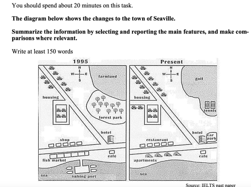
The image contains two diagrams of the town of Seaville, comparing its layout and infrastructure from 1995 to the present. The 1995 diagram features "housing" in the top left corner with a compass indicating north, "farmland" in the top middle, "forest park" in the top right, "shop" in the middle left, "hotel" in the middle, a "cafe" below the hotel, "fish market" in the bottom left, and "fishing port" in the bottom right, all in proximity to the "sea." In contrast, the present diagram shows "housing" again in the top left corner with a compass, "golf" in the top right, "housing" in place of the previous "shop," a "restaurant" where the hotel was, the "hotel" relocated to the bottom right with a "cafe" alongside it, a "car park" above the hotel, "tennis" in the middle right, and "apartments" now occupying the area previously designated as the "fish market," but with no reference to "fishing port" or sea. Both diagrams use symbols for trees, vehicles, and buildings, and include a labeled road cutting across from left to right.
Given the complexity of the image, the above description may not be entirely accurate.
Skyrocket your IELTS band score by 1-2 points in under a month with our premium plan!
Note: Both the topic and the answer were created by one of our users.
The maps above demonstrate the developments of Seaville that occurred in 1995 and the present.
Overall, the city experienced several changes, such as the expansion of residential areas, the demolition of some facilities, and the introduction of sports facilities.
To begin with, there are several changes in the southern part of the town. The commercial areas that contained shops and fish markets in 1995 were planned to be replaced with restaurants and new apartment buildings. Furthermore, the fishing port was demolished, leaving its place empty. Although the cafe remained untouched, there is the addition of facilities such as car parks in the eastern part of the hotel just next to it.
Moving to the northern part of the map, there are some additional buildings in the residential area and the replacement of green areas with sports facilities. The new houses were built across and beside the housing that was circled by the road, along with a new road. The green areas were converted to new sports faciltites, such as golf and tennis courts in the southern part close to the golf field.
Word Count: 182
