Our system will evaluate the answer based on this AI-generated description.
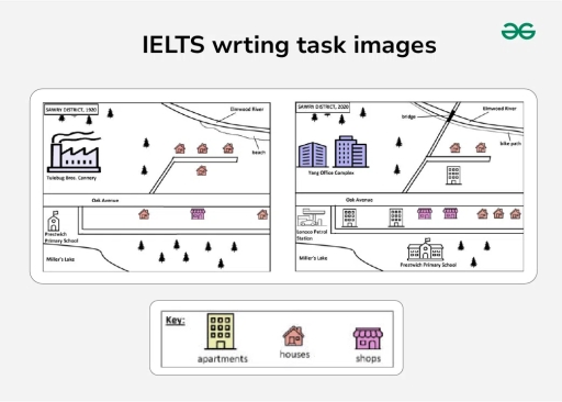
The image shows two adjacent district maps detailing structural layouts. Left map: "SAWN DISTRICT, 2000"; key symbols: houses (5), large building "Tishing Bees Cannery" near forest, "Elmwood River" at top, "Oak Avenue" running horizontally below cannery, one road branching from Oak Avenue to riverside, separate icon "Petwood Primary School" in southeast corner, "Millers Lake" in southwest corner. Right map: "SAWN DISTRICT, 2023"; key symbols: apartments (3), houses (5, same locations as 2000), shops (3); added structures: "Tsey Office Complex" northwest, "Secondary School" southwest adjacent to "Petwood Primary School," "Elmwood River" and parallel road intact, "Oak Avenue" retaining connection to residential area, new branching roads toward educational institutions between riverside and cannery area. Key at bottom specifies symbols.
Given the complexity of the image, the above description may not be entirely accurate.
Skyrocket your IELTS band score by 1-2 points in under a month with our premium plan!
Note: Both the topic and the answer were created by one of our users.
The two-map diagrams illustrate the residential estate’s development in the Sawry District between 1920 and 2020
Overall, it is notable that the town underwent significant transformation, becoming more urbanised with new residential apartments, employment complexes and commercial facilities.
Tulebug Bros Cannery, which was previously located in the northwest of the area, was replaced by the Yang Office Complex, while the surrounding trees were preserved. Regarding the northeast of the area, a newly constructed bridge was built across the Elmwood River, linking both sides of the river and connecting to Oak Avenue and the residential neighbourhoods. On the eastern side, the beach was replaced by a bike path, while the existing houses remained in the same locations, including a new apartment.
Oak Avenue remained unchanged through the centre of the area. Prestwich Primary School was relocated to the southern part of the area, reducing green space, while its former site was converted into a Lunoco petrol station. In addition, the residential area to the south of the avenue was expanded, establishing two apartment buildings, two shops and one house.
Word Count: 178
