Our system will evaluate the answer based on this AI-generated description.
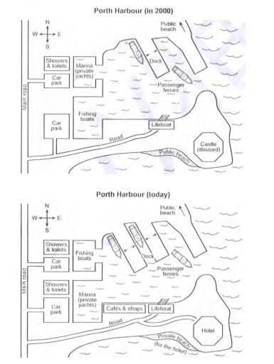
The image shows two plans, "Porth Harbour (in 2000)" and "Porth Harbour (today)", each with a compass (N at top). Both: Main road along the west edge; a Road from it east along the south shore to the Lifeboat building in the south centre; sea in the middle and east; "Public beach" with an arrow pointing north at top right; an angled Dock in the north centre with a ship to its west; Passenger ferries south-east of the dock. 2000: beside the main road, north to south, Showers & toilets, a Car park (side road from the main road), and a larger Car park (reached by a track from the Road); east of them a small basin, Marina (private yachts), and below it a larger basin, Fishing boats; Public beach on the south shore below the Road; Castle (disused) on the south-east headland. Today: beside the main road, north to south, Showers & toilets, Car park, a second Showers & toilets, and the larger Car park (now reached by a side road from the main road); Fishing boats in the small northern basin, Marina (private yachts) in the larger southern basin; a second angled dock just west of the original dock, where the first ship lies, with a second ship to the west of the new dock; Cafés & shops on the south shore west of the Lifeboat; the Road continues east with a branch to a Hotel on the south-east headland where the castle was; Private beach (for the hotel) on the south shore below the Road.
Given the complexity of the image, the above description may not be entirely accurate.
Skyrocket your IELTS band score by 1-2 points in under a month with our premium plan!
Note: Both the topic and the answer were created by one of our users.
The given maps show the changes in harbour in from 2000 to today.
Overall, the Porth Harbour undergoes with a significant number of changes over the given time period. The place of Fishing boats and Marine (private yachts) has been replaced and the Castle changes in hotel.
In 2000, the Porth Harbour has the specific things there was a main road in the end of west and a little away there was a car parking. Beside it there were showers and toilts. There was a marine (private yachts) on the right side of car parking. There was a public beach on the north easten side of the map. In the middle there was a passenger ferries. On the other side the main road lead to another car parking which is on westen side of map beside the parking there was a fishing boat and road ends on life boats. At last there was a Castle on the south easten corner of the first map.
In current days, approximately all the map look similar; there were some significant changes. For instance, the place of Fishing boats and Marine (private yachts) have been replaced also some cafes and shops are introduced now. At last Castle changes into hotel over the given time period.
Word Count: 211
