🔥 Today Only: Save 30% on Premium — Offer Ends Soon! - Upgrade Now!
Map

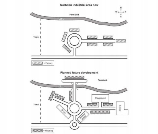
Band 5+: the maps below show an industrial area in the town of norbition. and planned future development of the site.

Image for topic: the maps below show an industrial area in the town of norbition. and planned future development of the site.
Our system will evaluate the answer based on this AI-generated description.
The image shows two diagrams, one labeled "Norbiton industrial area now" and another "Planned future development." The current industrial area features an elongated factory building located in the center, paralleled by a road to its left with four smaller rectangular structures (unlabeled) opposite it. Farmland spans the top extent of the diagram, with the town represented as a horizontally stretched rectangle at the bottom. The planned development diagram depicts a circular road system at the center with three branches; one leading to the town, one passing by two rectangular structures labeled as factories, and an extension to the farmland. Four separate housing units sit at the intersection, with a small labeled playground, delineated by dashed lines, placed to the right of farmland. The upper left section has a directional compass marking North (up), South (down), East (right), and West (left). No numerical data points or percentages are provided.
Given the complexity of the image, the above description may not be entirely accurate.
Note: Both the topic and the answer were created by one of our users.

The picture depicts the maps of a current manufacturing zone in Norbition with a future plan for addition construction.

Overall, there will be a significant development in the furture, including more streets and roundabout, the replacement of factory to housing, the cutting of the river, and more facilities in the town. However, there are a few site that remain the same on the map.

Major improvement in Norbition are: adding more streets that lead to new buildings and area like school, shops, Medical Centre , and playground. As well as, replace all factories to houses along the streets. One of the street also cut through the river to the farmland, which there is a huge housing building at the end of the street.

At the center of the industrial site, there is a big roundabout that stayed at the same spot. Athough, it use to be surrounded by factory, now surrounded by houses, a shop and a Medical Centre. Next to the big roundabout is a smaller one that connected to longest street in the maps.

Word Count: 176

Answers On The Same Topic:

the maps below show an industrial area in the town of norbition. and planned future development of the site.

The maps illustrate the current layout of the Norbiton industrial area and the proposed future redevelopment of the site. Overall, the town is expected to undergo substantial development, evolving from a town with farmland and factories to a town comprising medical centre, shops, housing, school, and playground. To begin with, Norbiton town is under developed […]

the maps below show an industrial area in the town of norbition. and planned future development of the site.

The map illustrates the current arrangement of an industrial zone in the city of Norbiton, and the expansion plans of the city, that is to be implemented in the future. Overall, it is evident that the site is to undergo several changes, including adding several amenities and diminishing some existing ones. As we can see, […]

the maps below show an industrial area in the town of norbition. and planned future development of the site.

The diagram illustrates the current and future layout of an industrial area in the town of Norbition. Generally, it can be seen that the site will witness a significant modernization. Most noticeably, the elimination of factories and the addition of several facilities and housing. Currently, the layout features a river, farmland and a number of […]

the maps below show an industrial area in the town of norbition. and planned future development of the site.

The two pictures compare the industrial zone of Norbiton as it is now with a purpose design for the future . Overall, the proposed plan requires a considerable amount of changes in the present town’s layout. These changes are mostly centered on the construction of new roads to provide better connectivity to the all facilities. […]

See All

Other Topics:

The maps below show a town centre in 1990 and the same town today.

The two maps illustrate the development of Town Centre, highlighting the key changes that occurred between 1990 and today. Overall, it is clear that the area underwent significant redevelopment, with several facilities being introduced and existing features being repurposed. Looking at the details, in the southern and southeastern side of the area, the houses were […]

The maps below show changes in the city of Nelson in recent times. Summaries the information by selecting and reporting the main features, and make comparisons where relevant.

The charts illustrates the difference of city Nelson in 2000 and today. Overall, the city has undergo considerably developed by constructing more buldings. Despite the modernization, the area has become residental. In 2000, most of the space in the city was empty, especially the port that occupied large free area. There was the road for […]

The maps below show some of the changes that have taken place in Duban in recent decades. Summarize the information by selecting the main features, and make comparisons. Note: You should use present perfect tense.

The provided maps illustrate the stuctual developments that have occured around the Clock Tower Roundabout in Dubai over recent decades Dubai in the past was quite empty and undeveloped ,with only a few houses located along a main road .That ran from northeast and rows of trees originally lined the outer sides of roads leaving […]

The maps show how a public building changed over different periods of time.

The maps illustrate how the layout and function of a public building changed over three periods, from a history reading room to a meeting room and ultimately a theatre. Overall, the building’s footprint expanded considerably at the expense of the garden, which eventually disappeared. The final layout contained a seating area and several supporting rooms, […]

The diagrams show how a district park looked ten years ago and how it looks now .

The two maps illustrate the development of District park, highlighting the key changes that occurred over a 10-year period between 2004 and 2014 Overall, it is clear that the area underwent significant redevelopment, with several new facilities being introduced and some existing features being removed or repurposed. In detail, a new cycling path was constructed […]

The diagrams show how a district park looked ten years ago and how it looks now .

The two maps illustrate the development of a District park, highlighting the key changes that occurred over a 10-year period between 2004 and 2014. Overall, it is clear that the area underwent significant redevelopment, with several new facilities being introduced and existing features being expanded or downsized. Looking at the details, a new cycling path […]

See All
We have detected unusual activity on your device.
Please verify your identity to continue.
Note: This verification step won't sign you in. If you have a premium account, please log in to access the service as usual.
Google/Gmail Verification
Or verify using Email/Code
We've sent a verification code to:
youremail@gmail.com (Not your email?)
Enter it below to complete the verification process.
Ensure your email address is correct, your inbox is not full, and you check your spam folder. If no email arrives, consider using an alternative email.
You will need a Premium plan to perform your action!
Note: If you already have a premium account, please log in to access our services as usual.

Plans & Pricing

Our mission is to make quality education accessible for everyone.
However, to keep our hardworking team running and this service alive, we genuinely need your support!
By opting for a premium plan, not only do you sustain us in achieving the mission, but you also unlock advanced features to enrich your learning experience.

Free

For learners who aren't pressed for time

What's included on Free
100+ Cambridge IELTS Tests
Instant IELTS Writing Task 1 & 2 Evaluation (2 times/month)
Instant IELTS Speaking Part 1, 2, & 3 Evaluation (2 times/month)
Instant IELTS Writing Task 1 & 2 Essay Generator (2 times/month)
500+ Dictation & Shadowing Exercises
100+ Pronunciation Exercises
Flashcards
Other Advanced Tools

Premium

For those serious about advancing their English proficiency, and for IELTS candidates aspiring to boost their band score by 1-2 points (especially in writing & speaking) in just 30 days or less

What's included on Premium
Save Your IELTS Test Progress & Analyze Mistakes By Question Type
Save Your Own Flashcard Sets & Use Them On Any Device
Unlock All Courses, IELTS Tests, Section & Part Practice
Unlimited AI Conversations
Unlimited AI Writing Enhancement Exercises
Unlimited IELTS Writing Task 1 & 2 Evaluation
Unlimited IELTS Speaking Part 1, 2, & 3 Evaluation
Checked Answers Will Not Be Published
Unlimited IELTS Writing Task 1 & 2 Essay Generator
Unlimited IELTS Speaking Part 1, 2, & 3 Sample Generator
Unlimited Usage Of Advanced Tools & AI Features
Priority Support within 24h (12-month plan only)

Due to the nature of our service and the provided free trials, payments are non-refundable.