Our system will evaluate the answer based on this AI-generated description.
The image shows two diagrams, one labeled "Norbiton industrial area now" and another "Planned future development." The current industrial area features an elongated factory building located in the center, paralleled by a road to its left with four smaller rectangular structures (unlabeled) opposite it. Farmland spans the top extent of the diagram, with the town represented as a horizontally stretched rectangle at the bottom. The planned development diagram depicts a circular road system at the center with three branches; one leading to the town, one passing by two rectangular structures labeled as factories, and an extension to the farmland. Four separate housing units sit at the intersection, with a small labeled playground, delineated by dashed lines, placed to the right of farmland. The upper left section has a directional compass marking North (up), South (down), East (right), and West (left). No numerical data points or percentages are provided.
Given the complexity of the image, the above description may not be entirely accurate.
Skyrocket your IELTS band score by 1-2 points in under a month with our premium plan!
Note: Both the topic and the answer were created by one of our users.
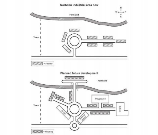
To The map below illustrates an industrial area and future development idea of a town in north Britain.
The map shows huge plans for the future developments, such as replacing factories with houses and adding important buildings that are in top of people’s needs.
In the present industry, There are factories on the east and centre as shown in the map, but in the future planning development some of the factories are replaced with housing and some of them with Medical Center shops and schools. Furthermore there are also more housings added to the West of the map and a big house in the farmland.
In the future map, more roads are built that goes along with houses and other buildings. River in the present map goes all the way without any cutoff but, Its planned to get cut off by a road going across the river.
Word Count: 147
