Our system will evaluate the answer based on this AI-generated description.
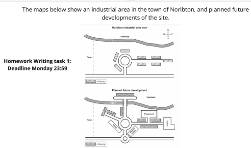
The image displays two layout maps showing "Norbiton industrial area now" and "Planned future development", accompanied by a four-point compass rose indicating North, South, East, and West. In the first map, labeled "Norbiton industrial area now", a wavy "River" runs east-west across the northern section with "Farmland" to its north, a vertical dashed line marks the "Town" boundary to the west, and a main horizontal road runs along the south; a central roundabout connects to the southern road and extends into an eastern branch, surrounded by eight rectangular sites designated by the legend as "Factory" (three sites northwest, north, and southwest of the roundabout, and five sites along the eastern road: two to the north, two to the south, and one at the eastern end). In the second map, labeled "Planned future development", factories are completely replaced by facilities and residential blocks designated by the legend as "Housing": the southern intersection includes a new smaller roundabout; the central roundabout connects to a southwest "Shops" building, a southeast "Medical centre", a newly built northwest branch road flanked by seven housing units, and a northern road extending across the "River" via a bridge into "Farmland" terminating in an east-west strip with one housing unit to the north and one along its western approach; the eastern road features a "Playground" to the north above two housing blocks, a long housing block along the south, and an L-shaped "School" at its eastern terminus.
Given the complexity of the image, the above description may not be entirely accurate.
Skyrocket your IELTS band score by 1-2 points in under a month with our premium plan!
Note: Both the topic and the answer were created by one of our users.
The two maps illustrate what the industrial area in town of Norbiton looks like today, and developments for future.
Overall, all an area town of Norbiton central is projected to a significant transformation with modern objects. The centre town of fully extended with modern objects.
At present, in terms of the central part of the map locate a central roundabout, that connected two main roads. The around a central roundabout are situated a lot of factories. Turning to the northern section situated a farmland and river.
Furthermore, in the future, a central roundabout will be extended with four main roads,allowing traffic to move in all direction and a new bridge to enable crossing the river. Consequently, all the factories will be replaced into housing, shops, medical centre, playground. The eastern side a central roundabout is planned to build playground, school, medical centre and modern housing. The western part a cental roundabout will be built shops and housing.
Word Count: 157
