🔥 Today Only: Save 30% on Premium — Offer Ends Soon! - Upgrade Now!
Map

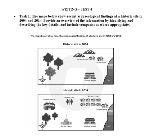
Band 5+: The maps below show recent archaeological findings at a historic site in 2004 and 2014. Provide an overview of the information by identifying and describing the key details, and include comparisons where appropriate.

Image for topic: The maps below show recent archaeological findings at a historic site in 2004 and 2014. Provide an overview of the information by identifying and describing the key details, and include comparisons where appropriate.
Our system will evaluate the answer based on this AI-generated description.
The image features two comparison maps titled "Historic site in 2004" and "Historic site in 2014", both containing a compass rose marked N, S, E, W in the lower-left corner and bordering the "Sea" along the eastern edge. In "Historic site in 2004", the western area features 3 trees; the northern area contains a mountain range and 2 buildings, each labeled "Ancient House"; and the southeastern region shows an "Ancient Temple". In "Historic site in 2014", the northwest contains an "Ancient Stadium"; north-center contains an "Ancient Toilet" marked with male and female figures; the northeast replaces the mountains with a cluster of 9 houses arranged in two rows of 4 plus 1 adjacent house, labeled twice as "Ancient House"; the southwest shows 2 trees; the south-central area adds an "Ancient Palace"; and the southeastern area retains the "Ancient Temple".
Given the complexity of the image, the above description may not be entirely accurate.
Note: Both the topic and the answer were created by one of our users.

The provide illustration in two maps demonstrate the diffrennce between the discoveries at an archaeological site near the sea in 2004 and some new findings in the year 2014.

Overall, it is shown that most of the new structures such as : an ancient palace, a stadium, more residential area and separate toilets for men and woman were discovered in 2004. While, in 2014 only an ancient temple, two houses were unearthed.

In 2004, only few houses, an ancient temple was excavated. In year 2014 only few ancient houses were found by the archeologists. 7 more houses were discovered by excavation of the mountains. The house built near the big ancient house in 2004 remained intact.It looked like an ancient village after 2014 discoveries. There was a forest in east direction and an ancient stadium were discovered in place of trees. The most significant discovery was the remains of toilets for both male and female used by ancient people near temple.

Word Count: 161

Answers On The Same Topic:

The maps below show recent archaeological findings at a historic site in 2004 and 2014. Provide an overview of the information by identifying and describing the key details, and include comparisons where appropriate.

The given two maps delineate the archaelogical findings at a historic place between 2004 and 2014. Overall, the historic site has been modernized over the decade. In addition, new infrastructures were built, whereas ancient temple and house were preserved. In 2004, there were three ancient houses in the northern part of the site and behind […]

The maps below show recent archaeological findings at a historic site in 2004 and 2014. Provide an overview of the information by identifying and describing the key details, and include comparisons where appropriate.

The maps illustrate how recent archaeological discoveries at a historic site changed between 2004 and 2014 . Overall , what is most striking when looking at the maps is that the area underwent a substantial transformation, primarily characterized by the excavation and uncovering of several ancient structures and public facilities. Meanwhile, the original woodland was […]

The maps below show recent archaeological findings at a historic site in 2004 and 2014. Provide an overview of the information by identifying and describing the key details, and include comparisons where appropriate.

The maps illustrate how recent archaeological discoveries at a historic site changed between 2004 and 2014 . Overall , what is most striking when looking at the maps is that the area underwent a substantial transformation, primarily characterized by the excavation and uncovering of several ancient structures and public facilities. Meanwhile, the original woodland was […]

The maps below show recent archaeological findings at a historic site in 2004 and 2014. Provide an overview of the information by identifying and describing the key details, and include comparisons where appropriate.

The pictures compare the recent archeological discoveries at the historic site- spanning over a ten-year period, starting from 2004 and ending in 2014. Overall, it can easily be seen that the historic site underwent significant changes over the period. Although the ancient template and some of the houses remained unchanged, numerous constructions had been built […]

See All

Other Topics:

Before and after the construction of some tourist attractions on an island

The two maps illustrate how the island developed before and after different construction for tourist relaxing. Overall, the island was transformed from a largely undeveloped natural area into a tourist destination. The island had only several pine trees before, while after a lot of constructions were built, . Moreover, several modern facilities were added, with […]

The plans below show the site of a farm in 1950 and the same site today. Summarize the information by selecting and reporting the main features, and make comparisons where relevant.

The maps compare the layout of Beechwood Farm in 1950 and the present day. Overall, the area underwent considerable development, with several new facilities being introduced and some existing facilities being relocated. Despite these changes, certain features such as the fruit trees, soft fruits and vegetanble shops remained unchanged. In the northeastern part of the […]

The diagram shows the fire escape plan for a student accommodation in the second floor of a college. Summarise the information by selecting and reporting the main features, and make comparisons where appropriate.

The given diagram provides information about the evacuation plan in the event of a fire for a college accommodation on the second floor. This plan outlines the locations of bedrooms, emergency exits and designated assembly points. Overall, the plan features two main meeting points and various evacuation routes, including stairs and a lift. The layout […]

The diagram below shows a town square and the surrounding area in 2024, and the plans for the development of the area to be completed by 2030. Summarise the information by selecting and reporting the main features, and make comparisons where relevant.

The diagram illustrate a map of a town square and it’s surrounding area in 2024 and the proposed blueprint of future development of the same area completed by 2030. Overall the comparison of the current situation and planning diagram reveals a complete transformation from a small calm area to a modern busy entertainment oriented townsquare. […]

The two maps below which show the area of barton Bingham in 1937 and 1995

The diagrams illustrate the significant development changes that took place in Barton Bingham between 1937 and 1995. Overall, it is clear that the area had been extensively modernized over nearly six decades. In agricultural land and scrubland spaces are entirely replaced by a leisure complex, a hospital and a car park. Specifically, In 1937, the […]

See All
We have detected unusual activity on your device.
Please verify your identity to continue.
Note: This verification step won't sign you in. If you have a premium account, please log in to access the service as usual.
Google/Gmail Verification
Or verify using Email/Code
We've sent a verification code to:
youremail@gmail.com (Not your email?)
Enter it below to complete the verification process.
Ensure your email address is correct, your inbox is not full, and you check your spam folder. If no email arrives, consider using an alternative email.
You will need a Premium plan to perform your action!
Note: If you already have a premium account, please log in to access our services as usual.

Plans & Pricing

Our mission is to make quality education accessible for everyone.
However, to keep our hardworking team running and this service alive, we genuinely need your support!
By opting for a premium plan, not only do you sustain us in achieving the mission, but you also unlock advanced features to enrich your learning experience.

Free

For learners who aren't pressed for time

What's included on Free
100+ Cambridge IELTS Tests
Instant IELTS Writing Task 1 & 2 Evaluation (2 times/month)
Instant IELTS Speaking Part 1, 2, & 3 Evaluation (2 times/month)
Instant IELTS Writing Task 1 & 2 Essay Generator (2 times/month)
500+ Dictation & Shadowing Exercises
100+ Pronunciation Exercises
Flashcards
Other Advanced Tools

Premium

For those serious about advancing their English proficiency, and for IELTS candidates aspiring to boost their band score by 1-2 points (especially in writing & speaking) in just 30 days or less

What's included on Premium
Save Your IELTS Test Progress & Analyze Mistakes By Question Type
Save Your Own Flashcard Sets & Use Them On Any Device
Unlock All Courses, IELTS Tests, Section & Part Practice
Unlimited AI Conversations
Unlimited AI Writing Enhancement Exercises
Unlimited IELTS Writing Task 1 & 2 Evaluation
Unlimited IELTS Speaking Part 1, 2, & 3 Evaluation
Checked Answers Will Not Be Published
Unlimited IELTS Writing Task 1 & 2 Essay Generator
Unlimited IELTS Speaking Part 1, 2, & 3 Sample Generator
Unlimited Usage Of Advanced Tools & AI Features
Priority Support within 24h (12-month plan only)

Due to the nature of our service and the provided free trials, payments are non-refundable.