Our system will evaluate the answer based on this AI-generated description.
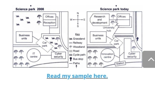
The image displays two maps titled "Science park 2008" and "Science park today", with a central compass rose indicating cardinal directions (N, S, E, W) and a "Key" defining seven symbols: "Grassland", "Railway", "Woodland", "Road", "Cycle path", "Bus stop", and "Paths". In "Science park 2008", the northwestern quadrant features grassland and woodland trees; the northeastern quadrant contains "Offices" with an attached "Reception"; the central area comprises "Business units", a dashed diamond-shaped "Car park", grassland, and woodland; the southwestern region holds a circular "IT centre" set within woodland; and the southeastern section includes a rectangular "Cyber security" building adjacent to a southern "Railway" and a eastern "Road" connected via "Paths". In "Science park today", a "Research and development" building occupies the northwestern area, a "University hub" replaces reception attached to "Offices", "Business units" remain, the "Car park" is re-linked by paths, the southwestern circle is labeled "Innovation centre" within woodland, "Cyber security" is expanded into an L-shaped structure, a "Station" is located on the southern railway line, "Cycle path" lines run parallel to the road network, and a "Bus stop" icon is placed on the eastern road.
Given the complexity of the image, the above description may not be entirely accurate.
Skyrocket your IELTS band score by 1-2 points in under a month with our premium plan!
Note: Both the topic and the answer were created by one of our users.
The two maps illustrate structural transformations and infrastructural developments in a science park from 2008 to the present day.Overall, the science park undergoes significant modernization with an increase in the number of buildings, the introduction of new transport infrastructure, and a reduction in grassland.
In 2008, the science park only had five buildings, but today the number of structures has risen to seven, alongside major reductions in the grassland.
Today, in place of the grassland, a new Research and Development building has been constructed. Moreover, the reception has been converted into a University Hub. Furthermore, the IT Centre has been redeveloped, and a new Innovation Centre has been erected. The area for Cyber Security has doubled in size, and a bus stop has been introduced on the right-hand side of the map. The last important modification on the current map is the installation of a station that was not present in the 2008 map.
Word Count: 154
