Our system will evaluate the answer based on this AI-generated description.
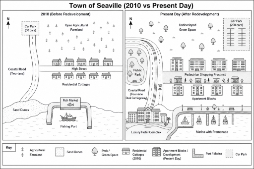
The image features two comparative layout maps titled "Town of Seaville (2010 vs Present Day)", each with a north compass indicator, accompanied by a key at the bottom. The left map, "2010 (Before Redevelopment)", shows a northwest "Car Park (50 cars)" linked to a north-south "Coastal Road (Two-lane)", which intersects an east-west "High Street" bordered by nine "Residential Cottages" (5 north, 4 south). The northern area consists of "Open Agricultural Farmland", the southwest coast contains "Sand Dunes", and the southern coastline features a rectangular-pier "Fishing Port" containing one fishing boat and a "Fish Market". The right map, "Present Day (After Redevelopment)", shows the northern section transformed into "Undeveloped Green Space" with trees, and the northeast corner housing a "Car Park (200 cars)". The west now features a "Public Park" with trees and a bench, curved around by an expanded "Coastal Road (Four-lane Dual Carriageway)" with an adjacent "Cycle lane". South of the road is a "Luxury Hotel Complex", while the central-eastern area contains a "Pedestrian Shopping Precinct" with pedestrian figures and shopfronts, flanked north and south by four apartment blocks each (eight total "Apartment Blocks"). The southern waterfront is converted into a "Marina with Promenade" with streetlamps, benches, trees, and four docked boats. The bottom key identifies symbols for "Agricultural Farmland", "Sand Dunes", "Park / Green Space", "Residential Cottages (2010)", "Apartment Blocks / Development (Present Day)", "Port / Marina", and "Car Park".
Given the complexity of the image, the above description may not be entirely accurate.
Skyrocket your IELTS band score by 1-2 points in under a month with our premium plan!
Note: Both the topic and the answer were created by one of our users.
The provided maps illustrate the redevelopment of the town of Seaville from 2010 to the present time.
Overall, the town has been transformed into a commercialised tourist and leisure destination, shifting away from its former status as a traditional low-density residential settlement. In addition, the infrastructure has undergone significant modernisation to accommodate higher residential density and expanded pedestrian facilities.
Along the south-western shoreline, the natural sand dunes visible in 2010 were replaced by a luxury hotel complex. Directly to the east, the working fish market and fishing port were decommissioned and converted into a recreational marina accompanied by an adjacent promenade. Furthermore, the high street between the previous residential cottages has been completely transformed into a shopping precinct for pedestrians. Towards the north, the open agricultural farmland is now designated as undeveloped green space.
On the western boundary, the previous two-lane coastal road was expanded into a four-lane dual carriageway along with a dedicated cycle lane. The original 50-car parking lot was redeveloped into a public park along the new coastal road, whereas a substantially larger 200-car capacity parking facility was newly added in the north-eastern corner. Finally, the row of modest residential cottages along the previous high street was redeveloped into multi-storey apartment blocks on both sides of the new shopping precinct.
Word Count: 213
