🔥 Today Only: Save 30% on Premium — Offer Ends Soon! - Upgrade Now!
Map

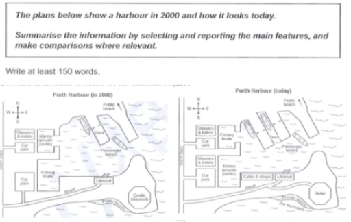
Band 5+: The maps illustrate the modifications that have occurred in Porth Harbour from 2000 to today.

Image for topic: The maps illustrate the modifications that have occurred in Porth Harbour from 2000 to today.
Our system will evaluate the answer based on this AI-generated description.
The image shows Porth Harbour maps for years 2000 and today, showing the following detailed changes. In 2000, notable features include a fishing port on the west side nearby to the sea, six boats within it, an adjacent fish market, and a café slightly eastward. There are three warehouses located at the southeast within the main boundaries along with a pier extending northwestward. A separate car park is located south of the boundaries, right next to the road leading to a final point with a children’s play area and hotel to the left. Significant changes visible today show the car park remaining but adjacent to it is a multi-storey car park; the surrounding play area converted into swimming pool. The hotel from 2000 now transformed into a "hotel with restaurant" establishment, and the warehouses haven been removed. The café is replaced by "cafés and shops". The fish market is now a maritime museum. The fishing port remains, but with three boats.
Given the complexity of the image, the above description may not be entirely accurate.
Note: Both the topic and the answer were created by one of our users.

The two maps describe what changes are noticed in Porth Harbour for the period from 2000 to now.

Overall, it is clear that the harbor has been redeveloped and modernized, with far more additional facilities.

First of all, the most important change is that the north-east side of the area is still used as a public beach, with one dock and two passenger ferries. However, the number of docks and passenger ferries increased by adding one more for each amenity. In terms of the south of the harbour, recreational facilities, such as a cafe and shops, have been introduced to the close-vicinity to lifeboats. The public beach is no longer open to the public, as a disused castle in the southeast has been turned into a hotel. Therefore, the beach is considered the property of the hotel nearby.

If we look at the north-west site, the marina which once used for private yachts, has been replaced with fishing boats; the reverse is true for fishing boats in the south-west part. Showers and toilets and a car park in the north-west and showers and toilets in the west have remained unaltered. Conversely, in the south, the other car park’s only access to the road has been changed by connecting to the main road in the west

Word Count: 215

Answers On The Same Topic:

The maps illustrate the modifications that have occurred in Porth Harbour from 2000 to today.

The maps give the information about the improvement of the Porth Harbour from 2000 to today. The first impression is that the Harbour today made use of more areas than in the past. It can be seen that there are several areas that still stay the same today as in 2000. These include the Carpark […]

The maps illustrate the modifications that have occurred in Porth Harbour from 2000 to today.

On this plan pictured a porth and how it looks nowadays. Perl-Harbour have the maintain road to come this place and looked from both sites- North and Sought. All structures had builded on East site. In 2000 to enter into the port, had a tho ways. First road ended in Car park, while Showers and […]

The maps illustrate the modifications that have occurred in Porth Harbour from 2000 to today.

The map illustrates a comparison between Porth Harbour in 2000 and today. Overall, there have been several changes, the most noticeable such as an increase in public and entertainment areas, as well as a reduction in a few accommodations. In 2000, the east of Porth Harbour area only had one dock with two accessible ferries […]

The maps illustrate the modifications that have occurred in Porth Harbour from 2000 to today.

The two maps delineate the alterations that Porth Harbour has undergone from the year 2000 to the present. It is evident that substantial transformations have occurred, including the introduction of new facilities, the repurposing of existing structures, and enhancements in both commercial and recreational areas, while core coastal infrastructures have largely remained intact. In 2000, […]

The maps illustrate the modifications that have occurred in Porth Harbour from 2000 to today.

The scheme visualizes Porth Harbour change over the years with comparison between plans for year 2000 and current-day one. Overall, the territory shifted from a general-use waterfront area to more of a tourist spot, with the according shifts in use of space. During its existence, the harbour has undergone a number of remarkable alternations. Foremost, […]

See All

Other Topics:

The present and future redevelopment of the university's sport centre

For the set of the maps illustrate the current layout of university sports centre and the proposed changes that are planned for the area in the future. Overall, the area is expected to undergo significant development, with several existing features being removed or replaced. The main changes will be the addition of sports hall, café, […]

The maps below describe a town in the Atlantic Ocean affected by a volcanic eruption in 1706. Summarise the information by selecting and reporting the main features and make comparison where relevant.

The maps illustrate the geographical changes experienced by a coastal town located in the Atlantic Ocean following a catastrophic volcanic eruption in 1706. Overall, the town was severely devastated by two successive phases of lava flows. The natural disaster not only destroyed key historical and residential infrastructure but also completely obliterated the town’s maritime trade, […]

The plans below show the layout of a town called Sholeaton in 1985 and in 2015.

The two maps compare the layout of a town called Sholeaton in 1985 and how it had changed by 2015. Overall, the town had undergone remarkable developments. The most noticeable transformations were in transport infrastructure and commercial facilities. One of the most striking changes was road system. To be more specific, there was the addition […]

The maps show the town of Wildan in 1990 and today. Summaries the information by selecting and reporting the main features and make comparisons where relevant.

The maps compares the differences of town of Wildan in 1990 and today. Overall, it is clear that Wilden has changed from an industrial area into a more residential area. Most of industrial sites have been replaced with houses and facilities, while the road and the river have remained same. In 1990, on the northern […]

The maps show the town of Wildan in 1990 and today. Summaries the information by selecting and reporting the main features and make comparisons where relevant.

The maps compares the differences of town of wildan in 1990 and today. Overall, it is clear that wilden has changed from an industrial area into a more residential area. Most of industrial siutes have been replaced with houses and facilities, while the road and the river have remained same. In 1990, on the northern […]

The diagram below shows a library before and after renovations.

The provided maps illustrate the layout changes that took place in Taftsville public library in the past and the present day. Overall, the library has undergone significant modernisation, featuring garden surrounded with greenary, magazines and expansion of reading zones. In the past, the main entrance situated at the bottom of the map, leading the parallel […]

See All
We have detected unusual activity on your device.
Please verify your identity to continue.
Note: This verification step won't sign you in. If you have a premium account, please log in to access the service as usual.
Google/Gmail Verification
Or verify using Email/Code
We've sent a verification code to:
youremail@gmail.com (Not your email?)
Enter it below to complete the verification process.
Ensure your email address is correct, your inbox is not full, and you check your spam folder. If no email arrives, consider using an alternative email.
You will need a Premium plan to perform your action!
Note: If you already have a premium account, please log in to access our services as usual.

Plans & Pricing

Our mission is to make quality education accessible for everyone.
However, to keep our hardworking team running and this service alive, we genuinely need your support!
By opting for a premium plan, not only do you sustain us in achieving the mission, but you also unlock advanced features to enrich your learning experience.

Free

For learners who aren't pressed for time

What's included on Free
100+ Cambridge IELTS Tests
Instant IELTS Writing Task 1 & 2 Evaluation (2 times/month)
Instant IELTS Speaking Part 1, 2, & 3 Evaluation (2 times/month)
Instant IELTS Writing Task 1 & 2 Essay Generator (2 times/month)
500+ Dictation & Shadowing Exercises
100+ Pronunciation Exercises
Flashcards
Other Advanced Tools

Premium

For those serious about advancing their English proficiency, and for IELTS candidates aspiring to boost their band score by 1-2 points (especially in writing & speaking) in just 30 days or less

What's included on Premium
Save Your IELTS Test Progress & Analyze Mistakes By Question Type
Save Your Own Flashcard Sets & Use Them On Any Device
Unlock All Courses, IELTS Tests, Section & Part Practice
Unlimited AI Conversations
Unlimited AI Writing Enhancement Exercises
Unlimited IELTS Writing Task 1 & 2 Evaluation
Unlimited IELTS Speaking Part 1, 2, & 3 Evaluation
Checked Answers Will Not Be Published
Unlimited IELTS Writing Task 1 & 2 Essay Generator
Unlimited IELTS Speaking Part 1, 2, & 3 Sample Generator
Unlimited Usage Of Advanced Tools & AI Features
Priority Support within 24h (12-month plan only)

Due to the nature of our service and the provided free trials, payments are non-refundable.