🔥 Today Only: Save 30% on Premium — Offer Ends Soon! - Upgrade Now!
Map

Band 6+: The maps provided illustrate structural alterations made in a seaside town starting 2000 and up until 2020.

Image for topic: The maps provided illustrate structural alterations made in a seaside town starting 2000 and up until 2020.
Our system will evaluate the answer based on this AI-generated description.
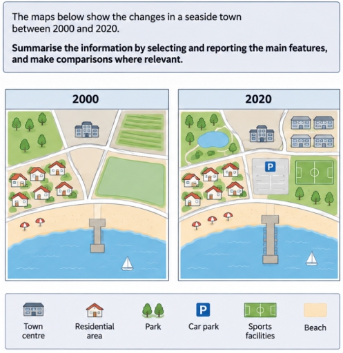
The image features two comparison maps titled "2000" and "2020", accompanied by a bottom legend identifying six key features: "Town centre" (building icon), "Residential area" (house icon), "Park" (two trees icon), "Car park" (blue square with letter 'P'), "Sports facilities" (green pitch icon), and "Beach" (beige icon). In the "2000" map, the layout contains a park with 8 trees in the northwest, a single town centre building in the north-central area, an agricultural field with horizontal green rows in the northeast, a residential area with 7 houses and 7 small green shrubs in the west, an empty triangular plot in the central junction, an enclosed plain green field in the east, a horizontal beach along the southern coastline featuring 2 red-and-white umbrellas, a short central pier extending into the water, and sea occupying the bottom with 1 sailboat in the southeast. In the "2020" map, the northwest area contains a park with 5 trees, walking paths, and a blue pond; the north-central area contains the same single town centre building; the northeast contains 4 apartment-style residential buildings; the west retains the residential area with 7 houses and 7 small shrubs; the central triangular plot is occupied by a rectangular car park marked with a 'P' icon and parking bays; the east features a sports facility consisting of a marked soccer pitch above 4 trees; the beach displays 3 red-and-white umbrellas; the central pier is lengthened further into the water; and the sea contains 1 sailboat in the southeast.
Given the complexity of the image, the above description may not be entirely accurate.
Note: Both the topic and the answer were created by one of our users.

The maps provided illustrate structural alterations made in a seaside town starting 2000 and up until 2020.

Overall, there has been a few significant changes set in place, however almost no demolitions happened over the period.

Starting 2000, west of the map’s center a residential area can be seen, over the road below it a beach and a bridge are located. Both east and north-east sections have their own dedicated spots to the empty grassy fields. Looking up north, a singular town centre has been constructed, with a park west of it.

Over the period of 20 years, the town has sustained a couple of renovations. While the residential area remained unchanged, the bridge by the shore has been extended by twice its original length. Simultaneously, east of the first town centre, a place that used to be empty, had seen multiple new identical buildings appear. Meanwhile, west of the original infrastructure, a new pond now takes up some of the park’s territory. When it comes to the east side of the map it has been altered in 3 different ways. A road west of the empty grass field has been demolished, with a new car park taking its place. The field itself has transformed into a sports facilities area, planting new trees below it for a new park.

Word Count: 219

Other Topics:

TASK 1 - The maps give information about a university sports court.

The provided maps demonstrates the transfomation of university sports court from 1990 to now. Looking from an overall perspective, it can be seen that one of the most significant changes happen in the park’s side which is converted into basketball court, whereas tennis court is replaced with changing room and new fitness area. Notably, instead […]

The maps below show the layout of a small town before and after a redevelopment plan. Summarise the information by selecting and reporting the main features, and make comparisons where relevant.

The maps illustrate a small town’s structure before and after a redevelopment plan. Overall, it can be seen that the town will undergo significant modernisation, with the removal of the factory and houses and their replacement with various residential and community facilities. Before the renovation, there was farmland just near a river, and the residential […]

The maps below show the changes to a community center in 10 years' time. Summarize the information by selecting and reporting the main features, and make comparisons where relevant.

The map illustrates how community centre had changed for 10 years. Overall, the map shows how it moderatly changed during 10 years. Firstly, the construction of building didn’t change absolutely, but some rooms, like storage, toilet and office switched from North to South. On the figure 1 in the North-western side there were the garden, […]

The maps below show the changes that have taken place in a town called Dalton over the past 25 years. Summarise the information by selecting and reporting the main features, and make comparisons where relevant.

The given maps illustrate the layout of Dalton town between 1995 and 2020. Overall, the town underwent significant changes over years, consisting of the demolitions of industrial estate and the school, and the construction of a new residentla area. In 1995, Dane river with a brigde at the bottom was extented from the south-east to […]

The two maps show the changes to an area of farmland between 2019 and 2023.

The two maps demonstrate the changes to a farmland between 2019 and 2023. In the area to the north of the river, the outdated farm buildings were demolished and has been converted into three holiday cottages by 2023. The greenfield which is to the east of the cottages was developed into a large villi where […]

See All
We have detected unusual activity on your device.
Please verify your identity to continue.
Note: This verification step won't sign you in. If you have a premium account, please log in to access the service as usual.
Google/Gmail Verification
Or verify using Email/Code
We've sent a verification code to:
youremail@gmail.com (Not your email?)
Enter it below to complete the verification process.
Ensure your email address is correct, your inbox is not full, and you check your spam folder. If no email arrives, consider using an alternative email.
You will need a Premium plan to perform your action!
Note: If you already have a premium account, please log in to access our services as usual.

Plans & Pricing

Our mission is to make quality education accessible for everyone.
However, to keep our hardworking team running and this service alive, we genuinely need your support!
By opting for a premium plan, not only do you sustain us in achieving the mission, but you also unlock advanced features to enrich your learning experience.

Free

For learners who aren't pressed for time

What's included on Free
100+ Cambridge IELTS Tests
Instant IELTS Writing Task 1 & 2 Evaluation (2 times/month)
Instant IELTS Speaking Part 1, 2, & 3 Evaluation (2 times/month)
Instant IELTS Writing Task 1 & 2 Essay Generator (2 times/month)
500+ Dictation & Shadowing Exercises
100+ Pronunciation Exercises
Flashcards
Other Advanced Tools

Premium

For those serious about advancing their English proficiency, and for IELTS candidates aspiring to boost their band score by 1-2 points (especially in writing & speaking) in just 30 days or less

What's included on Premium
Save Your IELTS Test Progress & Analyze Mistakes By Question Type
Save Your Own Flashcard Sets & Use Them On Any Device
Unlock All Courses, IELTS Tests, Section & Part Practice
Unlimited AI Conversations
Unlimited AI Writing Enhancement Exercises
Unlimited IELTS Writing Task 1 & 2 Evaluation
Unlimited IELTS Speaking Part 1, 2, & 3 Evaluation
Checked Answers Will Not Be Published
Unlimited IELTS Writing Task 1 & 2 Essay Generator
Unlimited IELTS Speaking Part 1, 2, & 3 Sample Generator
Unlimited Usage Of Advanced Tools & AI Features
Priority Support within 24h (12-month plan only)

Due to the nature of our service and the provided free trials, payments are non-refundable.