Willford Living Museum - IELTS Listening Answers & Explanations
From IELTS Trainer 2 Academic Listening Test 6 · Part 2 · Questions 11–20
Audio
Questions
Questions 11–15 Multiple Choice (One Answer)
Choose the correct letter, A, B or C.
Questions 16–20 Map Labeling
Label the map below.
Write the correct letter, A – H, next to Questions 16 – 20.
Answers & Explanations Summary
| # | Answer | Evidence | Explanation |
|---|---|---|---|
| Q11 | B | At that time, the forests had already been cut down. But there were no large urban settlements here, just a few small villages, and this whole area was a place where local people kept animals or grew crops – those were the only economic activities | Excerpt/Transcript Explanation: The transcript explains that there were no big towns and the trees were gone. Because people only used the land to raise animals and grow food (crops) to make money, the main use of the land was farming. Answer Explanation: The answer means that in the early 19th century, the land in Willford was mostly used for agriculture, like raising animals and growing food. Reason For Correctness: The correct answer is B because the guide explains that in the early 1800s, the trees (forests) were already gone and there were no large groups of buildings or houses. Instead, the area was used only for keeping animals and growing crops, which are common activities in farming. |
| Q12 | C | But then in 1830, something happened in Willford that transformed the area. The discovery of rich deposits of coal and other minerals opened up many commercial possibilities | Excerpt/Transcript Explanation: The transcript says that in 1830, the town changed because people found a lot of coal and minerals. Finding these materials meant the town could start new businesses. Answer Explanation: The answer means that in the year 1830, people found expensive or useful materials like coal deep in the earth. Reason For Correctness: The correct answer is C because the guide specifically mentions that 1830 was a major turning point for the town. During this year, 'rich deposits' of coal and minerals were discovered. In this context, 'rich deposits' refers to valuable substances, and finding them in the ground means they were found underground. This event led to the building of mines and changed the local economy. Other options like trains or ships are not mentioned as starting in 1830; the railway didn't come until the 1850s. |
| Q13 | A | However, what Willford was best known for, was manufacturing all sorts of tools, machinery and other items out of iron and steel | Excerpt/Transcript Explanation: The transcript says that Willford was most famous for making many different kinds of machines and tools out of metals like iron and steel. Answer Explanation: The answer means that the place called Willford was most famous for creating different things made from metal, such as tools and machines. Reason For Correctness: The correct answer is A because the speaker explains that while Willford made several things, it was "best known for" making tools and machinery using "iron and steel," which are metals. The phrase "best known for" means the same as "most famous for." The town also made fabrics (cloth) and tried to make pottery (clay items), but the metal items were what made the town truly famous. |
| Q14 | C | They now stand at 300,000 per year and we anticipate further growth in the years to come | Excerpt/Transcript Explanation: The transcript states that the current number of visitors is 300,000 each year and mentions that this number is expected to get even bigger. Answer Explanation: The answer means that about 300,000 people visit the museum every year. Reason For Correctness: The correct answer is C because the guide gives the current number of visitors per year. The guide says that right now (these days), the museum has 300,000 visitors every year. The speaker also mentioned that they expect even more people to come in the future. The other options involve calculations or different time periods that do not match the specific total given for a year. |
| Q15 | A | As well as that, those making movies and television shows often come to the museum because it makes a great set for historical scenes | Excerpt/Transcript Explanation: The transcript explains that people who produce films and TV programs use the museum because its old buildings look like a place from the past, which is perfect for their historical scenes. Answer Explanation: The answer means that the museum is used as a place where movies and TV shows are recorded. Reason For Correctness: The correct answer is A because the guide explains that filmmakers often visit the museum to use it as a background for historical stories. While the guide mentions 'weddings' as a future possibility, the use of the museum for 'movies and television shows' is described as something that happens often in the present. Keywords like 'movies,' 'television shows,' and 'set' (a place where filming happens) show that filming takes place there. |
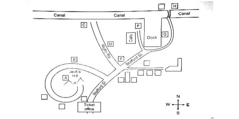
| Q16 | C | To get there from the ticket office, walk up Stafford Street. And then turn into Rigby Road. Walk down Rigby Road, there are a few interesting places along the way, and the old bakery is right next to the canal | Excerpt/Transcript Explanation: The transcript explains the route: start at the ticket office, go up Stafford Street, turn onto Rigby Road, and continue until you reach the bakery located beside the water. Answer Explanation: The answer is C, which is the spot on the map where the old bakery is found. Reason For Correctness: The correct answer is C because the guide gives directions starting from the ticket office. First, you walk up Stafford Street. Next, you turn into Rigby Road. Finally, you walk down that road to find the building that is right next to the canal (the water). On the map, C is the only building located on Rigby Road right beside the canal. |
| Q17 | F | Walk up Stafford Street, until you reach the dock. You see the café. Walk past that, and the doctor’s surgery is just there | Excerpt/Transcript Explanation: The transcript gives directions by telling the visitor to walk along Stafford Street to the water (the dock), pass the place where people buy food (the café), and then they will arrive at the doctor's building. Answer Explanation: The answer is the letter F, which marks the location of the doctor’s surgery on the map. Reason For Correctness: The correct answer is F because the guide explains how to get to the surgery from the ticket office. You walk up Stafford Street until you reach a water area called the dock. You will see a café there; if you walk past that café, the doctor's surgery is the next building. |
| Q18 | A | Walk up Stafford Street and take the first turning on the left. The road curves round to the west, then south, as it climbs Jack’s Hill. You’ll pass a few little houses on the way up, and Cooper’s Cottage is right on the summit of Jack’s hill | Excerpt/Transcript Explanation: The transcript gives step-by-step directions: first walk up the main street (Stafford Street), take the first left, follow the road as it bends around Jack’s Hill, and look for the cottage at the highest point of that hill. Answer Explanation: The answer, which is letter A, shows where Cooper’s Cottage is located on the museum map. Reason For Correctness: The correct answer is determined by following the guide's directions from the ticket office. The guide explains that to reach Cooper’s Cottage, you must walk up Stafford Street and take the very first left turn. The road then bends to the west (left) and then south (down) while going up a hill named Jack’s Hill. The cottage is situated at the very top, or 'summit', of this hill. On typical map layouts for this task, the letter A fits this specific description of taking the first left and following a curved path to a high point. |
| Q19 | H | The stables are also great. This is where they kept all the horses. Again, walk up Stafford Street to the dock, and turn right. Walk round the dock till you get to the canal. Then cross the bridge over the canal to reach the stables | Excerpt/Transcript Explanation: The transcript gives directions to the place where horses live: start on Stafford Street, go to the dock, go right, follow it to the canal, and then walk over the bridge. Answer Explanation: The answer is the letter H, which marks the location of the stables on the museum map. Reason For Correctness: The correct answer is H because the guide provides a step-by-step path to find the stables. To reach them, you must walk up Stafford Street until you hit the dock (the water area), turn right, walk around the water to find the canal, and finally walk across the bridge. On a map with these landmarks, location H is found by following these specific turns. |
| Q20 | E | Also, be sure to visit the old school. So, walk north-east up through the museum. And it’s not too far. The old school is right on the corner of Stafford Street and Rigby Road | Excerpt/Transcript Explanation: The transcript explains that to find the old school, you should walk north-east. It is located at the place where Stafford Street and Rigby Road cross each other. Answer Explanation: The answer is E because it represents the location of the old school on the map. Reason For Correctness: The correct answer is E because the guide provides specific directions to find the old school. You must walk north-east through the museum from the starting point. The landmark's exact position is described as being on the corner where Stafford Street and Rigby Road meet. |
Transcript
Guide: Well good morning everyone and a warm welcome to the Willford Living Museum. Before you look around, I’d like to tell you a bit about the history of Willford, and the purpose of the museum.
Well, if we go back to the early 1800s, Willford was very different to what you see today. At that time, the forests had already been cut down. But there were no large urban settlements here, just a few small villages, and this whole area was a place where local people kept animals or grew crops – those were the only economic activities.
But then in 1830, something happened in Willford that transformed the area. The discovery of rich deposits of coal and other minerals opened up many commercial possibilities. Mines were built, so these deposits could be brought to the surface. Then a canal was constructed, so that canal boats could transport the minerals to other regions. Finally. a railway was built through Willford in the 1850s, creating many new opportunities.
By the 1870s, Willford had become an important manufacturing centre. A few factories successfully produced fabrics from cotton and wool.
However, what Willford was best known for, was manufacturing all sorts of tools, machinery and other items out of iron and steel. The attempt to set up a pottery industry here, however, making items for the home out of clay, was never really a success.
So, for the next hundred years or so, Willford was a thriving industrial region. However, by the 1970s, the old industries here were in decline. Much of the land at this site wasn’t being used. So the local council decided to set up a ‘living’ museum here. The idea was for visitors to be able to walk around and visit the sorts of factories, shops, homes and schools that were once found here.
When the museum first opened in 1976, 2000 visitors came on the first weekend alone. Since then, visitor numbers have just grown and grown. They now stand at 300,000 per year and we anticipate further growth in the years to come. In fact, just recently we welcomed our 9 millionth visitor, which was an exciting day for us.
As well as our regular visitors, the museum has a number of other uses. We work closely with universities, whose staff consult the range of documents and artefacts we hold here. As well as that, those making movies and television shows often come to the museum because it makes a great set for historical scenes. There’s even a possibility in future we may open up the museum for weddings and other private events.
Guide: OK, so if you take out your maps, I’ll just point out a few places you might like to visit. So right now, we’re standing in the ticket office, at the bottom of your maps.
So, one place I’d recommend is the old bakery. This is a typical bakery from this area, from about 100 years ago. To get there from the ticket office, walk up Stafford Street. And then turn into Rigby Road. Walk down Rigby Road, there are a few interesting places along the way, and the old bakery is right next to the canal.
Another interesting place is the doctor’s surgery. This was moved here, brick by brick, and rebuilt on the museum site. Walk up Stafford Street, until you reach the dock. You see the café. Walk past that, and the doctor’s surgery is just there.
Cooper’s Cottage is also fascinating – a worker’s cottage from the 19th century. Walk up Stafford Street and take the first turning on the left. The road curves round to the west, then south, as it climbs Jack’s Hill. You’ll pass a few little houses on the way up, and Cooper’s Cottage is right on the summit of Jack’s hill.
The stables are also great. This is where they kept all the horses. Again, walk up Stafford Street to the dock, and turn right. Walk round the dock till you get to the canal. Then cross the bridge over the canal to reach the stables.
Also, be sure to visit the old school. So, walk north-east up through the museum. And it’s not too far. The old school is right on the corner of Stafford Street and Rigby Road.
Now one other thing…