Our system will evaluate the answer based on this AI-generated description.
The image contains two schematic diagrams labeled "Before" and "After," illustrating the layout of an unspecified area. In the "Before" diagram, the layout has an "office" with two sections labeled "staff changing room" and "director board," an area marked as "entrance underground (for workers)" connected directly to the "office," two "waste tip" sites labeled as "waste tip 1" and "waste tip 2" near the top part of the diagram, and a "parking area" designated as "car parking" positioned at the left-hand side. In the "After" diagram, the configuration includes a "museum" to the right, a central "cafe," a new "entrance underground (for visitors)" linked to a path labeled "digging driving track" running around the museum, an adapted "parking area" in the same position as before but not designated specifically as car parking, a "picnic area" outlined with a dotted line in the lower right, and at the far left, a "litter park" and a "children play area." No numerical data points or percentages are presented in either diagram.
Given the complexity of the image, the above description may not be entirely accurate.
Skyrocket your IELTS band score by 1-2 points in under a month with our premium plan!
Note: Both the topic and the answer were created by one of our users.
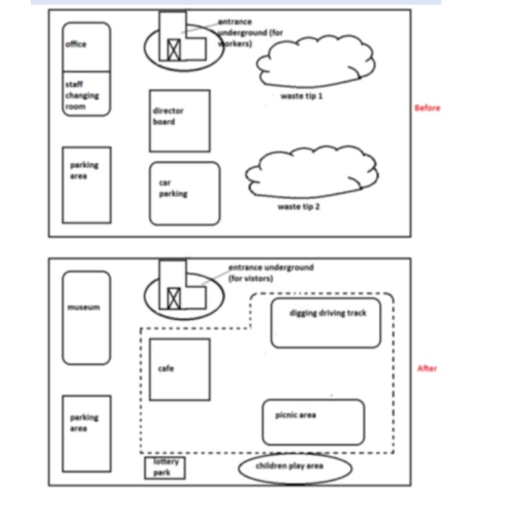
The given map illustrates an active mining area before and after a plan of redevelopment that transformed it into a tourist attraction. It can be seen that this area has been modernized due to more facilities and services, as well as improving the transportation.
In terms of the western area, the area, which used to be a place for an office and a staff changing room, has been demolished and converted into a museum. However, the car park, which is located in the southwest of the map, remains completely unchanged. In addition, the entrance to the underground mine, which was accessible only by workers, is now open for visitors.
Regarding the center area, there is a footpath that has been built around the center area. To serve more travelers, tourism facilities like a cafe and souvenir shop have been built in the area where the medical room and lorry park used to be. Furthermore, located in the east of the map, two waste tips were removed to give place for the digger driving track, picnic area, and children’s play are
Word Count: 180