Our system will evaluate the answer based on this AI-generated description.
The image displays two diagrams depicting the current and planned development of Norbiton industrial area; the current map includes six factories, marked as rectangles, connected via a circular road intersection with smaller roads leading to each factory, a town lies to the west across the Fanfield river which runs from west to east, the layout indicates direct road connectivity between the factories and region north of river; in the planned future development map, same circular road expands to include designated zones for housing, medical center, playground, school, further road expansions towards north and east connecting housing units alongside factories while allocated spaces like medical center on southern side, playground on southeastern, and school on northeast adjoining the housing sector, housing areas on west across river from factories alongside assumption of persistent factory, town regions unchanged from existing map.
Given the complexity of the image, the above description may not be entirely accurate.
Skyrocket your IELTS band score by 1-2 points in under a month with our premium plan!
Note: Both the topic and the answer were created by one of our users.
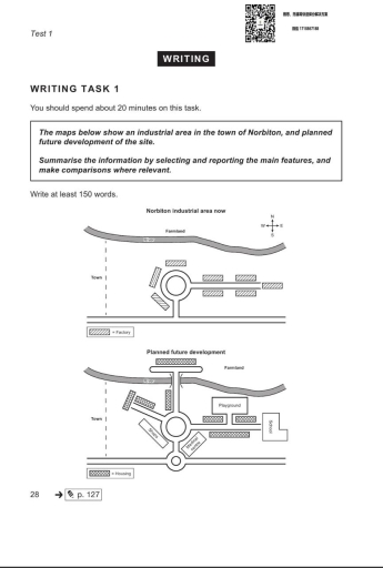
The two maps illustrate the layout of an industrial area in the town of Norbiton as it is now and how it is planned to be developed in the future.
Overall, the area is expected to experience a significant changes, shifting from a primarily industrial zone to a residential district. New infrastructure including a bridge, medical and educational facilities, as well as housing and shops, will be introduced.
Currently, there is no bridge across the river to the north, and the farmland on the other side remains unused. However, the development includes the construction of a new bridge, providing access to the northern side, where additional housing will be built. Moreover the new segment of the road will appear in the northwestern part of the roundabout .
The roundabout remains the central point of the layout, but in the new plan, several new roads branch out from it, providing direct access to different residential areas. A newly constructed street will lead eastward to a school and a playground, both located among a cluster of houses. Another road extends southward to a medical centre, while the western part of the area will include shops and additional housing.
Word Count: 196