🔥 Today Only: Save 30% on Premium — Offer Ends Soon! - Upgrade Now!
Map

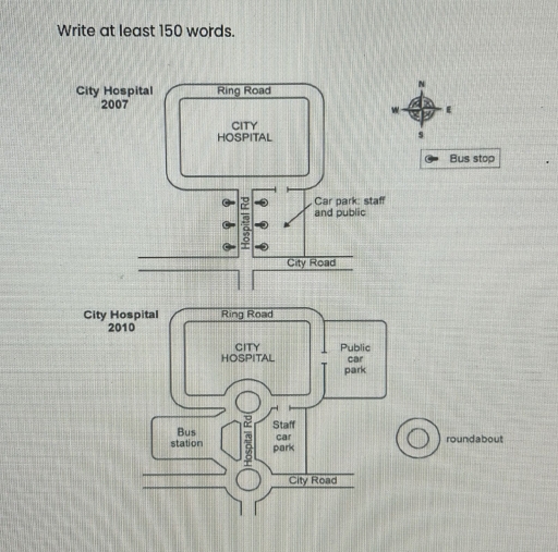
Band 6+: Task 1: The two maps below show road access to a city hospital in 2007 and 2010. Summarize the information by selecting and reporting the main features and make comparisons wherever relevant. Write at least 150 words.

Image for topic: Task 1: The two maps below show road access to a city hospital in 2007 and 2010. Summarize the information by selecting and reporting the main features and make comparisons wherever relevant. Write at least 150 words.
Our system will evaluate the answer based on this AI-generated description.
The image depicts two maps of City Hospital from 2007 and 2010, showing infrastructure changes. In 2007, the hospital is surrounded by the Ring Road, with Hospital Road running south from the hospital intersecting City Road. There are three bus stops along Hospital Road to the east and south. The car park for staff and public is to the southeast of the hospital and connects to City Road. By 2010, a roundabout has been introduced at the hospital's southern entrance where Hospital Road meets City Road. A new road extends east from the roundabout, leading to a dedicated public car park located northeast of the hospital. The original hospital car park has been redesignated for staff only. A bus station has replaced the former bus stops and is positioned southwest of the hospital, connected via another roundabout on Hospital Road. The map includes a compass in the top-right corner indicating north, with a bus stop and roundabout symbol marked in the legend.
Given the complexity of the image, the above description may not be entirely accurate.
Note: Both the topic and the answer were created by one of our users.

The provided maps present the development of the road access to a city hospital between 2007 and 2010.

Overall, it is clear to see that there were major improvements in the road, involving a new bus station, new roundabouts and new car parks. Additionally, the modification aimed at managing the traffic better.

One of the changes was that the roundabout was added at the T-junction of the ring road and hospital road and at the four-way intersection of the hospital road and city road. On the east side of the hospital road, the bus stops disappeared and the staff car park was added.

Another transformation involved the removal of the bus stop on the west side of the hospital road for a bus station. A new public car park was constructed in the east of the city hospital that joined the ring road.

Word Count: 143

Answers On The Same Topic:

Task 1: The two maps below show road access to a city hospital in 2007 and 2010. Summarize the information by selecting and reporting the main features and make comparisons wherever relevant. Write at least 150 words.

Those maps illustrate changes at road access to a city hospital comparing 2007 and 2010. Overall, the town underwent significant development, with more residential areas and new roads appearing over the period. New buildings and areas for car parking were established. Road has been extended in order to connect city hospital and bus station. In […]

Task 1: The two maps below show road access to a city hospital in 2007 and 2010. Summarize the information by selecting and reporting the main features and make comparisons wherever relevant. Write at least 150 words.

The maps illustrate the previous layout of road access to a local hospital and how it appeared following renovation in 2010. In 2007, the City Road was situated on the south side. Just before reaching the hospital, there was a narrow hospital road with six bus stops, three on each side. To the east of […]

Task 1: The two maps below show road access to a city hospital in 2007 and 2010. Summarize the information by selecting and reporting the main features and make comparisons wherever relevant. Write at least 150 words.

The two maps illustrate changes that have taken place at the city hospital over a 3-year period between 2007 and 2010. Overall, the city hospital has undergone remarkable modifications to its road infrastructure and several surrounding areas. According to the first map, in 2007 there were bus stops along the hospital road (road towards city […]

Task 1: The two maps below show road access to a city hospital in 2007 and 2010. Summarize the information by selecting and reporting the main features and make comparisons wherever relevant. Write at least 150 words.

The two maps shown below are the comparison of road access to the city hospital in 2007 and 2010. By looking at these two layout, we can observed that the road which was made in 2007 was much simple but the 2010 one is much better in terms of managing the traffic. In 2007, the […]

See All

Other Topics:

The two maps below show a town before and after some changes. Write a summary of the main changes. Try to include the following: 1 description of the main changes. 2 comparative and superlative adjectives

The maps illustrate the city changes from 2007 to 2017. Overall, it is immediately apparent that the city has undergone significant redevelopment. The buildings become enormously bigger. Necessary buildings have been increased and more space has been allocated to facilities. Looking at the earlier map, the most prominent features were a school on the right […]

the map shows the change of pentland from 1980 to 2007

The map illustrate the diversity of Pentland between 1980 and 2007. Overall,a yacht marina was built in place of the sea in 2007.The swimming pool was constructed in front of the marina.Furthermore,car park was moved to the western part of Pentland.A road was built near the coast of marina. Houses stood on the south-east corner […]

The maps below present the changes that have taken place at the Southwest Airport since its reconstruction in the unnamed year.

The layouts of Southwest Airport demonstrate the site now and after modernization. Overall, the most significant facts to emerge from the maps are that after the redevelopment, the number of gates will more than double with the addition of two wings. As a result, the terminal’s capacity will expand heavily to handle more passengers next […]

The maps below describe a town in the Atlantic Ocean affected by a volcanic eruption in 1706. Summarise the information by selecting and reporting the main features and make comparison where relevant.

The diagrams provide information about how a port town in the Atlantic Ocean transformed after a volcanic eruption in 1706. Overall, the natural disaster caused various changes to the town, with the most noticeable ones being the loss of inland housing as well as the hindrance of maritime activities. The town was situated to the […]

the map show how the ground floor of a cẻtain building has changed over time

These three maps demonstrate the transformation of a building’s ground floor throughout the years, starting off in 1958 to the present day. Overall, a lot of modifications were made regarding the purpose of the floor as well as its layout. However, the entrance of the building along with the kitchen area remain mostly the same […]

The two maps below show an island, before and after the construction of some tourist facilities Summarise the information by selecting and reporting the main features, and make comparisons where relevant.

At glance, the map illustrates the island’s before and after phase concerning the construction of tourist facilities. Overall, there seems a stark difference in the before and after phase. The island did not go under any development in its former stage. Conversely, the latter phase witnessed a plethora of infrastructural developments to transform it into […]

See All
We have detected unusual activity on your device.
Please verify your identity to continue.
Note: This verification step won't sign you in. If you have a premium account, please log in to access the service as usual.
Google/Gmail Verification
Or verify using Email/Code
We've sent a verification code to:
youremail@gmail.com (Not your email?)
Enter it below to complete the verification process.
Ensure your email address is correct, your inbox is not full, and you check your spam folder. If no email arrives, consider using an alternative email.
You will need a Premium plan to perform your action!
Note: If you already have a premium account, please log in to access our services as usual.

Plans & Pricing

Our mission is to make quality education accessible for everyone.
However, to keep our hardworking team running and this service alive, we genuinely need your support!
By opting for a premium plan, not only do you sustain us in achieving the mission, but you also unlock advanced features to enrich your learning experience.

Free

For learners who aren't pressed for time

What's included on Free
100+ Cambridge IELTS Tests
Instant IELTS Writing Task 1 & 2 Evaluation (2 times/month)
Instant IELTS Speaking Part 1, 2, & 3 Evaluation (2 times/month)
Instant IELTS Writing Task 1 & 2 Essay Generator (2 times/month)
500+ Dictation & Shadowing Exercises
100+ Pronunciation Exercises
Flashcards
Other Advanced Tools

Premium

For those serious about advancing their English proficiency, and for IELTS candidates aspiring to boost their band score by 1-2 points (especially in writing & speaking) in just 30 days or less

What's included on Premium
Save Your IELTS Test Progress & Analyze Mistakes By Question Type
Save Your Own Flashcard Sets & Use Them On Any Device
Unlock All Courses, IELTS Tests, Section & Part Practice
Unlimited AI Conversations
Unlimited AI Writing Enhancement Exercises
Unlimited IELTS Writing Task 1 & 2 Evaluation
Unlimited IELTS Speaking Part 1, 2, & 3 Evaluation
Checked Answers Will Not Be Published
Unlimited IELTS Writing Task 1 & 2 Essay Generator
Unlimited IELTS Speaking Part 1, 2, & 3 Sample Generator
Unlimited Usage Of Advanced Tools & AI Features
Priority Support within 24h (12-month plan only)

Due to the nature of our service and the provided free trials, payments are non-refundable.