Our system will evaluate the answer based on this AI-generated description.
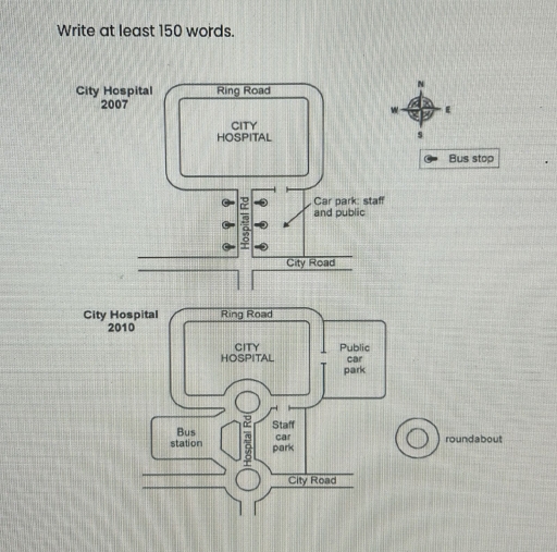
The image depicts two maps of City Hospital from 2007 and 2010, showing infrastructure changes. In 2007, the hospital is surrounded by the Ring Road, with Hospital Road running south from the hospital intersecting City Road. There are three bus stops along Hospital Road to the east and south. The car park for staff and public is to the southeast of the hospital and connects to City Road. By 2010, a roundabout has been introduced at the hospital's southern entrance where Hospital Road meets City Road. A new road extends east from the roundabout, leading to a dedicated public car park located northeast of the hospital. The original hospital car park has been redesignated for staff only. A bus station has replaced the former bus stops and is positioned southwest of the hospital, connected via another roundabout on Hospital Road. The map includes a compass in the top-right corner indicating north, with a bus stop and roundabout symbol marked in the legend.
Given the complexity of the image, the above description may not be entirely accurate.
Skyrocket your IELTS band score by 1-2 points in under a month with our premium plan!
Note: Both the topic and the answer were created by one of our users.
The two maps illustrate changes that have taken place at the city hospital over a 3-year period between 2007 and 2010.
Overall, the city hospital has undergone remarkable modifications to its road infrastructure and several surrounding areas.
According to the first map, in 2007 there were bus stops along the hospital road (road towards city hospital) and a car park for both staff and the public to the left of it. However, by 2010 the previous area of the car park has changed its role, serving only for staff, and the second car park has been developed to the right of city hospital for public. Furthermore, all the bus stops have been removed and a new bus station has been added to the left of the hospital road, which is linked by two new roundabouts.
Having said that, previously in 2007 there were not any roundabouts, but by 2010 the cross sections of the roads has been replaced by them. The first roundabout has been developed just in front of the city hospital in the centre of the map, and the second one has been added in the bottom of the map, in the cross section of two roads(the hospital road and the city road).
Word Count: 205
