Our system will evaluate the answer based on this AI-generated description.
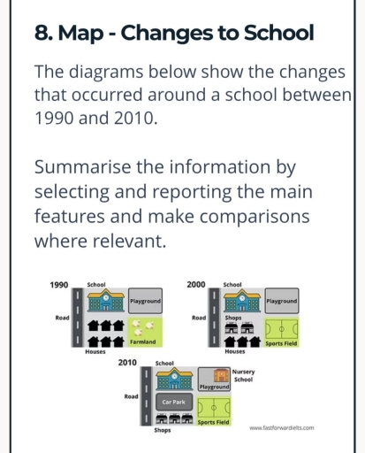
The image presents three layout diagrams corresponding to the years 1990, 2000, and 2010, each bounded on the left by a vertical strip labeled "Road". In 1990, the layout contains "School" in the upper-left quadrant, "Playground" in the upper-right quadrant, "Houses" (depicted with 6 house icons arranged in two rows of 3) in the lower-left quadrant, and "Farmland" (with sheep icons) in the lower-right quadrant. In 2000, the upper-left retains "School" and the upper-right retains "Playground"; the lower-left section contains "Shops" (2 shop icons) above "Houses" (3 house icons), while the lower-right quadrant features "Sports Field". In 2010, "School" occupies the upper-left; the upper-right quadrant contains "Playground" adjacent to a building labeled "Nursery School"; the lower-left section features "Car Park" situated above "Shops" (3 shop icons); and the lower-right quadrant contains "Sports Field".
Given the complexity of the image, the above description may not be entirely accurate.
Skyrocket your IELTS band score by 1-2 points in under a month with our premium plan!
Note: Both the topic and the answer were created by one of our users.
The maps show the changes which happened around a school between 1990 and 2010.
Overall, the area became more developed during this period. The main changes were the replacement of the farmland by a sports field, the appearance of shops and a car park, and a nursery school was also built. The school and playground stayed in the same places.
In 1990, there was a school in the northern part of the area, next to the road. A playground was located to the right of the school. There were six houses in the southern part and farmland was situated on the right side of the houses.
By 2000, the farmland had been changed into a sports field. Also, shops were built between the school and the houses. The houses were still in the southern part, although their position was a little different. The playground and school did not change.
In 2010, more changes happened. The houses were removed and shops were placed at the bottom of the map. A car park was built between the road and the school. Also, a nursery school appeared next to the playground. The sports field stayed in the same place.
Word Count: 196
