Our system will evaluate the answer based on this AI-generated description.
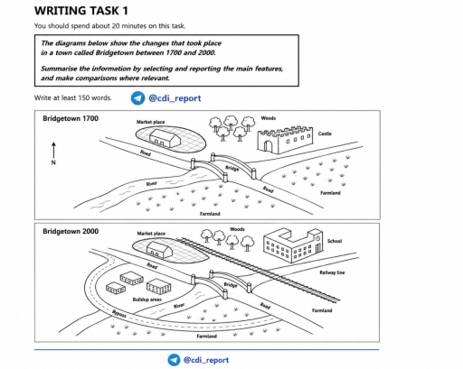
The image features two comparison maps of a town: "Bridgetown 1700" and "Bridgetown 2000", with a north arrow pointing up. In "Bridgetown 1700", a "River" flows horizontally across the lower-middle section, crossed by a "Road" via a "Bridge" running diagonally from northwest to southeast; north of the road are a "Market place" with a single building inside an oval plot to the northwest, "Woods" (four trees) in the north-center, and a "Castle" with battlements to the northeast; south of the river and road are labeled "Farmland" in both the south-central and southeastern areas. In "Bridgetown 2000", the "Market place", "Road", and "Bridge" remain; a "Railway line" runs diagonally from northwest to southeast passing between the Market place/Woods and the Road, crossing over the Road east of the Bridge; the Castle is replaced by a multi-story "School" with a clock tower next to the "Woods"; to the southwest between the Road and River, three new structures are labeled "Buildup areas"; a curving "Bypass" road connects to the main Road on the west, crosses the River, loops around the buildup areas and south of the river, and reconnects to the Road east of the Bridge; "Farmland" remains in the southern strip below the bypass and in the southeastern section below the railway line.
Given the complexity of the image, the above description may not be entirely accurate.
Skyrocket your IELTS band score by 1-2 points in under a month with our premium plan!
Note: Both the topic and the answer were created by one of our users.
The provided map illustrates the changes that took place in a town called Bridgetown over a span of 300 years from 1700 to 2000.
Overall, the town had undergone several fundamental changes over the period, becoming more advanced and livable place. Notably, the city transportation infrastructure was significantly improved by 200 and most of the changes took place on western part.
In 1700, the Bridgetown was old and less advanced city. To explain most of its areas on south and western side were being used for agricultural purposes, in the form of farmlands. There was a bridge in the middle of the town that connects farmlands living areas over a river which flows from right corner of the map to the bottom. The market place was situated next to the bridge on the left side and just near the market there was a castle, along the river.
By 2000 the experienced many dramatic changes become more advanced. The castle was replaced by school whereas market place remained intact with trees behind it. However, there was new railway line built, stretching from east to west, just next to the bridge road.
On the eastern part of the town under the road, new buildup areas took place in there was and, new curved road named Bypass was constructed around those areas. Finally, other parts of the town remained unchanged.
Word Count: 227
