Our system will evaluate the answer based on this AI-generated description.
The image features two comparison maps of a town: "Bridgetown 1700" and "Bridgetown 2000", with a north arrow pointing up. In "Bridgetown 1700", a "River" flows horizontally across the lower-middle section, crossed by a "Road" via a "Bridge" running diagonally from northwest to southeast; north of the road are a "Market place" with a single building inside an oval plot to the northwest, "Woods" (four trees) in the north-center, and a "Castle" with battlements to the northeast; south of the river and road are labeled "Farmland" in both the south-central and southeastern areas. In "Bridgetown 2000", the "Market place", "Road", and "Bridge" remain; a "Railway line" runs diagonally from northwest to southeast passing between the Market place/Woods and the Road, crossing over the Road east of the Bridge; the Castle is replaced by a multi-story "School" with a clock tower next to the "Woods"; to the southwest between the Road and River, three new structures are labeled "Buildup areas"; a curving "Bypass" road connects to the main Road on the west, crosses the River, loops around the buildup areas and south of the river, and reconnects to the Road east of the Bridge; "Farmland" remains in the southern strip below the bypass and in the southeastern section below the railway line.
Given the complexity of the image, the above description may not be entirely accurate.
Skyrocket your IELTS band score by 1-2 points in under a month with our premium plan!
Note: Both the topic and the answer were created by one of our users.
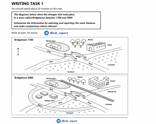
The given maps illustrate the changes that occurred in a town called Bridgetown over 300 years period.
Overall, Bridgetown underwent significant modernization, shifting from a simple rural community centered around a castle to a more developed area with new infrastructure such as a new school and a railway line, as well as a bypass.
In 1700, the town was largely undeveloped, with the castle and woods located on the northeast side and a marketplace positioned north of a road which crossed a river via a bridge. Farmland was located on both sides of the main road of the town.
By 2000, several noticeable changes occurred in the town. The main alteration was a castle that was converted completely into a school, which retained its position. Another significant change we can see is a railway line that was constructed across the main river, whereas the built-up areas were added to the left side of the road, surrounded by the bypass on its southwest side, which passed through the river and attached to the road. The farmland was more compacted and surrounded the whole south side of the town. Nevertheless, there were also some places that remained unaltered throughout the period, such as the marketplace, road, and bridge, as well as the river, which can now serve more specific purposes.
Word Count: 218
