🔥 Today Only: Save 30% on Premium — Offer Ends Soon! - Upgrade Now!
Map

Band 7+: The map below shows the change in the town of Dalton between 1815 and 2015

Image for topic: The map below shows the change in the town of Dalton between 1815 and 2015
Our system will evaluate the answer based on this AI-generated description.
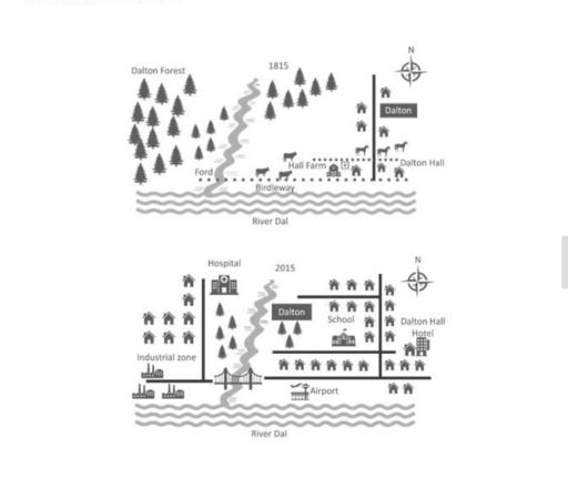
The image presents two maps comparing a location in years 1815 and 2015. In 1815, features include Dalton Forest to the northwest, a river labeled River Dal flowing south, a ford crossing the river, Birdwey with three houses south of the ford, Hall Farm to the east with two houses, Dalton Hall situated east of Birdwey, a cluster of six trees, and two roads connecting these landmarks including Dalton at the far northeast. By 2015, Dalton is expanded in the center with three rows and two columns of houses around it, additional east-west roads line the area. Newly introduced facilities include a hospital to the northwest, an industrial zone to the west along the river, a bridge replacing the ford, an airport south of the river, and a hotel southwest of Dalton Hall, along with a school situated directly east of Dalton, maintained trees to the northwest and north of River Dal, and the river retains a similar course southward.
Given the complexity of the image, the above description may not be entirely accurate.
Note: Both the topic and the answer were created by one of our users.

The development of Dalton over 2 centuries since the year 1815 is shown by the 2 maps provided. Over this time span, the rural village has undergone significant urbanisation and vastly changed its local economy.

In the first map, Dalton is shown to be a rather remote settlement, supporting only a few homes along a road, with stables separating the town hall and the farms from the main living quarters. The end of the street connects to the river-facing Bridleway path, leading to Ford beyond a tributary to river Dal.

In 2015, Dalton does away with the cattle farming, and becomes a bustling city capable of hosting its own airport. Many new roads have been paved to provide access to even more homes. Many new projects have come on to Dalton, including a Hospital, a school, and a hotel in the town hall. A modern bridge extends the town over the smaller river to its industrial zone.

Word Count: 157

Answers On The Same Topic:

The map below shows the change in the town of Dalton between 1815 and 2015

The provided maps illustrate the structural changes made to the town of Dalton between 1815 and 2015. Overall, the town experienced major changes in its layout and the town has become more residental and industrial, with many new facilities introduced while lost its some of environmental objects. In 1815, the town was relatively simple, with […]

The map below shows the change in the town of Dalton between 1815 and 2015

In 1815 town named Dalton had the perfect, dense forest over the river. There was several farms with cows, horses. Seems quite strange but they had houses below ten. They didn’t have any schools, hospitals and else while in 2015 they have improved a lot! Now, there is a bridge across the river. So many […]

The map below shows the change in the town of Dalton between 1815 and 2015

The map given illustrates the differences in main features in the town of Dalton between the years 1815 and 2015. Overall, it is clear that the town has urbanised significantly within the span of two hundred years. In 1815 ,there were few man made structures and most of such structures were located in the East. […]

The map below shows the change in the town of Dalton between 1815 and 2015

The diagram presents a comparison of the town of Dalton between the years 1815 and 2015. Overall, the town of Dalton has undergone significant changes from 1815 to 2015. In the figure, we can observe that various physical infrastructures have been established between 1815 and 2015. Notable developments include an industrial zone, airport, hospital, hotel, […]

See All

Other Topics:

The maps below show the changes experienced by Riverside town from 1970 to 2010.

The maps provided delineate the transformations that have transpired in Riverside town between the years 1970 and 2010. In summary, Riverside has undergone significant development, with notable expansions in its residential, recreational, and transportation infrastructure, while certain original features have remained intact. In 1970, Riverside town comprised a central business district bordered by a residential […]

Writing Task 1 You should spend about 20 minutes on this task. The pictures show the changes of a park from 1980 to the present day. Summarize the information by selecting and reporting the main features and make comparisons where relevant. You should write at least 150 words.

The represented maps illustrate how the park has changed from 1980 till now. Overall, the major alterations are the implementation of tables for lunch and the rearrangement of the spaces for different activities. It is evident that the park are substantially renovated and ultilized. Initially, the park was close by a wall all around the […]

The maps below show the village of Richardson Pike in 1995 and present day.

The maps illustrates how the village of Richardson Pike was changed between 2 years: 1995 and now. Overall, the village underwent significant urbanization, with the development of commercial and residential areas, at the expense of farmland and a forest park to meet people’s needs. Focusing on Jasper Street, by comparison, housing areas are extended towards […]

The map below shows the changes that have taken place at a zoo in Australia between 1960 and now. Summarize the information by selecting and reporting the main features, and make comparisons where relevant.

The map illustrates some developments at a zoo between 1960 and now. Overall, a seal show, birds, chimpanzees, picnic areas, gift shop, Australian animals and African animals were available in 1960, while significant transformations have taken place since then. However, new facilities s have been built by the present day like the ferry, entrance and […]

IELTS task 1 Map of a Park The map below describes changes to a park in 1980 and now.

The map illustrates the changes that have taken place in a park from 1980 to the current day. Overall, the park has witnessed a significant transformation. It mainly used to be a greenery zone at a time, however, following the redevelopment, it has become a recreational area, with the introduction of eating facilities including desks, […]

See All
We have detected unusual activity on your device.
Please verify your identity to continue.
Note: This verification step won't sign you in. If you have a premium account, please log in to access the service as usual.
Google/Gmail Verification
Or verify using Email/Code
We've sent a verification code to:
youremail@gmail.com (Not your email?)
Enter it below to complete the verification process.
Ensure your email address is correct, your inbox is not full, and you check your spam folder. If no email arrives, consider using an alternative email.
You will need a Premium plan to perform your action!
Note: If you already have a premium account, please log in to access our services as usual.

Plans & Pricing

Our mission is to make quality education accessible for everyone.
However, to keep our hardworking team running and this service alive, we genuinely need your support!
By opting for a premium plan, not only do you sustain us in achieving the mission, but you also unlock advanced features to enrich your learning experience.

Free

For learners who aren't pressed for time

What's included on Free
100+ Cambridge IELTS Tests
Instant IELTS Writing Task 1 & 2 Evaluation (2 times/month)
Instant IELTS Speaking Part 1, 2, & 3 Evaluation (5 times/month)
Instant IELTS Writing Task 1 & 2 Essay Generator (2 times/month)
500+ Dictation & Shadowing Exercises
100+ Pronunciation Exercises
Flashcards
Other Advanced Tools

Premium

For those serious about advancing their English proficiency, and for IELTS candidates aspiring to boost their band score by 1-2 points (especially in writing & speaking) in just 30 days or less

What's included on Premium
Save Your IELTS Test Progress
Unlock All Courses & IELTS Tests
Unlimited AI Conversations
Unlimited AI Writing Enhancement Exercises
Unlimited IELTS Writing Task 1 & 2 Evaluation
Unlimited IELTS Speaking Part 1, 2, & 3 Evaluation
Checked Answers Will Not Be Published
Unlimited IELTS Writing Task 1 & 2 Essay Generator
Unlimited IELTS Speaking Part 1, 2, & 3 Sample Generator
Unlimited Usage Of Advanced Tools
Priority Support within 24h (12-month plan only)

Due to the nature of our service and the provided free trials, payments are non-refundable.
Nếu bạn là người Việt Nam và không có hoặc không muốn trả bằng credit/debit cards, bạn có thể thanh toán bằng phương thức chuyển khoản:


Chọn gói:
419,000₫ 277,000 ₫ cho gói 1 tháng (chỉ 9,233₫/ngày)
1,239,000₫ 597,000 ₫ cho gói 3 tháng (chỉ 6,633₫/ngày)
2,469,000₫ 1,027,000 ₫ cho gói 6 tháng (chỉ 5,706₫/ngày)
4,929,000₫ 1,417,000 ₫ cho gói 12 tháng (chỉ 3,936₫/ngày)


Sau khi chuyển khoản, vui lòng đợi trình duyệt tự động điều hướng bạn trở lại Engnovate và bạn sẽ ngay lập tức nhận được mã kích hoạt tài khoản premium.
Nếu có lỗi xảy ra, bạn có thể liên hệ với team thông qua một trong các phương thức: email đến helloengnovate@gmail.com hoặc nhắn tin qua facebook.com/engnovate.
Vì toàn bộ công cụ trên website đều có thể sử dụng thử miễn phí, Engnovate không hỗ trợ hoàn tiền.