Our system will evaluate the answer based on this AI-generated description.
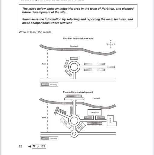
The image depicts two maps illustrating the current layout and planned future development of Norbiton industrial area. The current map features a town to the south and farmland to the northwest with a road connecting them. The industrial area in the center contains six segmented rectangular structures labeled as factories, positioned along the central circular road. There are linear roads extending from the circle toward the four corners of the map. The planned future development map shows the same farmland, but introduces additional elements such as housing and a playground. Housing is depicted as three rectangular units located at the southern domain near the town. A playground and a road labeled "planned future development" span across the new layout. The circular road remains with non-specific labeled structures, adding one rectangular structure labeled "school" and another labeled "medical center" adjacent to the existing layout. No numerical data points or percentages are visible in either map.
Given the complexity of the image, the above description may not be entirely accurate.
Skyrocket your IELTS band score by 1-2 points in under a month with our premium plan!
Note: Both the topic and the answer were created by one of our users.
The two maps illustrate various future changes that will be made to an industrial area in Norbiton town.
Overall, all the factories will be removed and replaced by houses and local services, while numerous pathways will be supplemented with new construction added to the farmland.
Towards the east side of the map, several factories on each side of the road will be replaced by houses, with an addition of a playground on the north-east side and a school at the end of the road. To provide service for future residents, a medical center will be constructed along side with a small roundabout to the entrance of the area.
Specifically, the removal and replacement of several facilities will also be witness on the west side of the map. Aside from the shops superseding a factory on the south-west side of the roundabout, a new road and multiple homes located to the north-west side of the town will be added. Moreover, a northbound route extending from the main roundabout in the central of the town will be erected across the river to give access to new houses on the farmland.
Word Count: 188
