Our system will evaluate the answer based on this AI-generated description.
The image depicts two diagrams showing roads and infrastructure in a town named Moleson. The first diagram represents the current layout with a main road running horizontally with two roundabouts; a minor street diverges north between the roundabouts, paralleled by a pedestrian path on its left. Four shops (S1-S4) are located north of this minor street, while S5 is positioned south between the roundabouts alongside a parking space P1. The second diagram illustrates a proposed layout where the main road is supplemented with a parallel pedestrian-only pathway directly above it, introduced with three parallel jog paths north between the roundabouts. Additionally, the minor street is removed, the northern roundabout gives access to a dual-lane road leading east towards two large buildings labeled B1 and B2, encompassing an additional parking area P2 directly west of these structures, while the school and bus stop remain situated at the southern end of the same dual-lane road.
Given the complexity of the image, the above description may not be entirely accurate.
Skyrocket your IELTS band score by 1-2 points in under a month with our premium plan!
Note: Both the topic and the answer were created by one of our users.
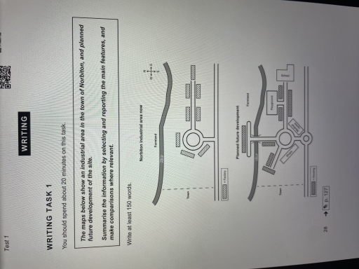
The two maps show the current layout of the industrial area in Norbiton and its planned future redevelopment. Overall, the area is expected to undergo a complete transformation, changing from an industrial zone into a residential area with improved infrastructure and public facilities.
At present, the area consists mainly of factories, which are located on both sides of a circular road connected to the main road running west to east. There is also a river flowing along the northern edge, and farmland located beyond the river.
In the future development plan, all factories will be removed and replaced by housing units. The southern part of the circular road will host shops, a medical centre, and more housing. A new road will be built to the northeast, crossing the river via a bridge and providing access to additional housing and farmland. A school and a playground will also be built in the northeastern part, improving the quality of life for families. The transformation will significantly improve the livability of the area, turning it into a well-equipped residential community.
Word Count: 177
