Our system will evaluate the answer based on this AI-generated description.
The image provides two diagrams: one illustrating the current state of the Norbiton industrial area, and the other showing the planned future development of the same area. In the current state, the diagram shows the industrial area composed primarily of factories, located to the north of a town (deemed "Town" in the diagram), and adjacent to farmland stretching towards the east. In the future development plan, the industrial area appears to be undergoing transformation with the addition of housing to the west of the factories, a playground to the north, surrounded by additional housing, and the farmland remaining largely untouched. The road system in both diagrams displays a roundabout with a single road branching directly from it towards the east, with the road labeled [20'9"']. Both diagrams orient Northwards and employ conventional map symbols: solid rectangles to denote factories, grid patterns for housing, and dotted outline to indicate a playground, with the remaining area assumed to represent farmland. No numerical data points, percentages, or specific quantitative measures aside from the road label "[20'9"] are provided.
Given the complexity of the image, the above description may not be entirely accurate.
Skyrocket your IELTS band score by 1-2 points in under a month with our premium plan!
Note: Both the topic and the answer were created by one of our users.
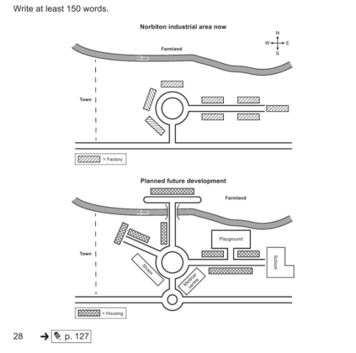
The maps illustrate the current layout of the Norbiton industrial area and its proposed redevelopment in the future.
Overall, the area will undergo a complete transformation from an industrial zone into a residential neighbourhood. All existing factories will be replaced by housing, and the infrastructure will be significantly expanded with new facilities and roads.Looking at the changes in detail, the basic road layout with its central roundabout will be modified. A new smaller roundabout will be constructed on the southern main road. From the central roundabout, a new road will extend southwest to provide access to a line of shops, while a medical centre will be built just to the southeast. Furthermore, a school will be established at the eastern end of the area, situated next to a newly added playground and surrounded by residential housing blocks.
In the northern part of the area, the farmland beyond the river will be partially developed. A new bridge will be built over the river, connecting the main housing area to a new residential block on the north bank. The factories currently surrounding the central roundabout and lining the eastern road will all be cleared to make way for these new housing units
Word Count: 200
