Our system will evaluate the answer based on this AI-generated description.
The image depicts two maps of Harton from 2008 and 2016. In 2008, features include a residential area in the northwest, derelict warehouses to the east, Old Town south of the warehouses, woodland to the east of Old Town, and a large lake further east. South of the residential area is an arts center, with two separate residential areas further south and an industrial complex at the center near a river. By 2016, the area transforms; the northwest remains residential, the warehouses become a car park and offices, the Old Town converts to multi-storey housing, and a university appears where the school previously existed. The woodland shrinks, replaced partially by a pond. The river still flows to the south, with a shopping center replacing one residential area, and the expansion of the industrial complex occupies the other former residential sector.
Given the complexity of the image, the above description may not be entirely accurate.
Skyrocket your IELTS band score by 1-2 points in under a month with our premium plan!
Note: Both the topic and the answer were created by one of our users.
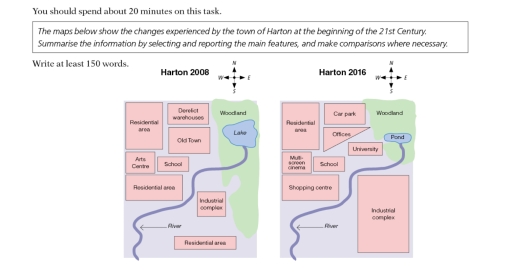
The maps above illustrates the transformation of the town, harlot in between the years, 2008 and 2016. Overall, the town underwent multiple big constructions, changing from an old town to a more modernized one with the addition of places such as cinema and shopping malls.
First and foremost, the north area experienced massive changed. The old derelict warehouses, east of the housing area was converted into a veichle parking facility, the residential area remained untouched whereas, the old town next to it was developed into a small office center. A university was constructed just west of the ponf and woodland area.
Furthermore, south of the residential area witnessed even greater changed. For instances, the arts centre back in 2008 was replaced by a multi screen modern theater and just to the south west of the cinema was converted into another housing facility that was reconstructed into a shopping mall. In the south east of the map, the small industrial complex was expanded, replacing the residential area south east of the river and taking almost half of the woodland in the east.
Word Count: 181
