Our system will evaluate the answer based on this AI-generated description.
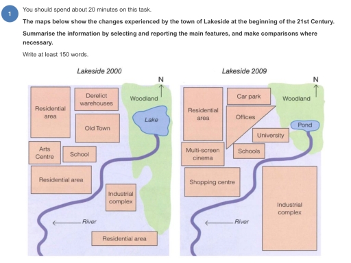
The image presents two maps comparing the town of Lakeside between the years 2000 and 2009. The maps are oriented with a north indicator. In the 2000 map, the town comprises a large lake in the center, surrounded by the Old Town and residential areas. Notably, there's a derelict warehouse zone adjacent to the Old Town. A river flows alongside and partly encircles the town’s southern boundary. The south-west section includes an industrial complex and another residential area. A central residential zone sits south of the lake, while an Arts Centre and School are located in the south-east.
By 2009, Lakeside underwent several changes. While the lake and river maintain their presence, the derelict warehouses have been replaced by a car park, offices, and a university. The original woodland near the lake remains unchanged, but a new pond appears east of the lake. The multi-screen cinema and shopping center are new additions, located adjacent to the river in what was a simple, unlabeled expansion space. The south-western industrial complex and southern residential zones appear unaltered. The Arts Centre of 2000 has been replaced, or possibly incorporated, with schools in the 2009 map. Such transformations reflect urban redevelopment focusing on enhancing educational facilities and commercial activity while maintaining some green spaces like woodland and adding new water features such as the pond.
Given the complexity of the image, the above description may not be entirely accurate.
Skyrocket your IELTS band score by 1-2 points in under a month with our premium plan!
Note: Both the topic and the answer were created by one of our users.
The provided maps depict the changes in the town of Lakeside over a period of nine years between 2000 and 2009.
At a glance, it can be clearly seen that most changes happened on the northwest part of the map; however, the locations of river, woodland, and residential area remained unchanged.
To begin with, on the southeast side of the map, there were small industrial complex and residential area, but they were altered into the big industrial complex. Moreover, the lake was converted to the pond on the northeast side of the map.
On the northwest side of the map, however, derelict warehouses, school, and old town were replaced with car park, offices, schools, and university. By contrast, there was no change in the location of residential area. In addition, there were arts Centre and residential area on the western side of the map, but they were altered with multi-screen cinema and shopping Centre.
Word Count: 154
