Our system will evaluate the answer based on this AI-generated description.
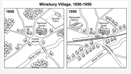
The image features two maps titled "Winsbury Village, 1850-1950", contrasting the village layout between "1850" and "1950". In the 1850 map, labeled features include "church" and "market square" at a central road junction, "Harwood House" to the east, "Spurlon Farm" to the northeast, and "River Arlon" running across the southern area, surrounded by wooded areas in the northwest, west, and south, along with a few scattered houses along the roads. In the 1950 map, labeled features include "Glassware factory" in the northwest, "Harwood Hotel" (occupying the former site of Harwood House), and "River Arlon" spanned by a bridge to the southeast. Additional developments in 1950 include an east-west railway line with a station near the central junction, new rows of residential houses replacing Spurlon Farm and line the roads to the south and northeast, while the church remains intact and the original trees and market square label are removed.
Given the complexity of the image, the above description may not be entirely accurate.
Skyrocket your IELTS band score by 1-2 points in under a month with our premium plan!
Note: Both the topic and the answer were created by one of our users.
These maps illustrate the had taken in Winsbury village between the year 1850 and 1950
Overall, several changes was made between 1850 and 1950, a new rail way was constructed in the village which ran from east to west. More house were added in the open area as well as glassware factory was built by cutting forest area. The market square in the middle of the village was converted in the simple road.
In 1850, there was a hardwood house at the centre of the village just next to the market square. In addition, church was located in the left side of house and spurton farm was at the back of the hardwood house.There was a river flowing through the area at the lower side, flowing in south-east direction. Small roads were throughout the village which were connected with market square and lots of trees were located in the different part of the local area.
By, 1950 serveral changes were made, the market square was remove and a railway was constructed, passing that area. Moreover, in the upper right glassware factory was built by cutting the trees. spurton farm was converted to residential areas and hardwood hotel in the from of it was remained same along with church at the left. All the trees were cut from every side in order to added some construction things.
Word Count: 226
