Our system will evaluate the answer based on this AI-generated description.
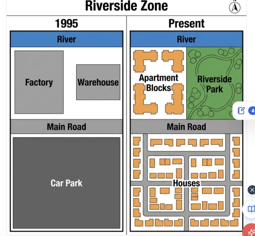
The image features two comparative layout plans titled "Riverside Zone" accompanied by a north arrow pointing upward, illustrating spatial configurations in "1995" and "Present". Both maps display a full-width horizontal "River" along the northern boundary and a full-width horizontal "Main Road" dividing the northern and southern halves. In the 1995 map, the section north of Main Road contains a large rectangular "Factory" on the west and a smaller square "Warehouse" on the east against open ground, while the entire southern half is occupied by a single extensive rectangular "Car Park". In the Present map, the area north of Main Road is divided into two sections: the western sector features four angled structures forming an enclosure labeled "Apartment Blocks", and the eastern sector is occupied by "Riverside Park" containing winding pathways and tree foliage symbols. South of Main Road, the former car park is replaced by an internal street network labeled "Houses", comprising 47 individual rectangular residential buildings organized into perimeter alignments (5 on the far west, 5 on the far east, 5 along the north road, and 6 along the southern border) surrounding four interior quadrangles containing 7, 6, 7, and 6 units, respectively.
Given the complexity of the image, the above description may not be entirely accurate.
Skyrocket your IELTS band score by 1-2 points in under a month with our premium plan!
Note: Both the topic and the answer were created by one of our users.
The pictures illustrate the map of Riverside Industrial Area in 1995 and its current blueprint as a community resident. Overall, while the fabric and the warehouse were demolished, apartment blocks and a riverside park are constructed near the river. Beside that, houses are also built, replacing the the car park.
Looking into the Riverside maps in 1995, the car park took place the whole south area which was around a half of the Riverside zone. Meanwhile, the factory and the warehouse located in the north side. In addition, a main road separated those area.
In the current map, the apartment blocks are constructed near the river, in the site where the factory were used to be there. Beside that, the warehouse is completely vanish and it is replaced by the riverside park. While the main road is still unchanged, homes are built in the north side, replacing the parking area
Word Count: 150
