🔥 Today Only: Save 30% on Premium — Offer Ends Soon! - Upgrade Now!
Map

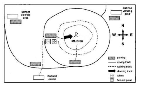
Band 7+: The maps below show tourists a number of di#erent ways of visiting Mount Eron in a national park. Summarise the information by selecting and reporting the main features, and make comparisons where relevant.

Image for topic: The maps below show tourists a number of di#erent ways of visiting Mount Eron in a national park. Summarise the information by selecting and reporting the main features, and make comparisons where relevant.
Our system will evaluate the answer based on this AI-generated description.
The image displays a map centered on Mt. Eron, with a compass rose indicating North, South, East, and West. The map features a Sunset viewing area in the northwest, a Sunrise viewing area in the northeast, and a Cultural center in the south. There is a western base area containing one toilets facility and one first-aid point. A network of paths includes one circular driving track connecting four parking areas, one walking track that encircles the mountain's mid-section, a second walking track connecting the cultural center to the western base area, and one climbing track leading from the western base area to the summit of Mt. Eron. The four parking areas are situated near the sunset viewing area, the sunrise viewing area, the western base area, and south of the mountain. A legend defines symbols for parking, driving track, walking track, climbing track, toilets, and first-aid point.
Given the complexity of the image, the above description may not be entirely accurate.
Note: Both the topic and the answer were created by one of our users.

The map displays various options of exploring the Eron mountain in a nature reserve.

Looking from an overall perspective, it is readily apparent that apart from the mountain Eron the national park offers two sunset viewing areas and a cultural center along with four car parking areas. Additionally, there is number of both walking and driving tracks.

The Eron mountain, surrounded by a walking a track, is located in the central part of the park. There is a parking zone along with toilets and a first-aid point to the west of the mountain. Another car park close to the mountain can be found south to the mountain. This car park is connected to a walking track around the mountain, while the other has a walking track near it that leads straight to the top of Eron. In addition, the mountain is surrounded by a driving track that passes through various areas of the nature reserve.

Two sunrise viewing areas are located on the west and the east parts of the national park. There are two car parks adjacent to the viewing areas. A cultural center is located south-west to Eron and has a walking track connected to the one that surrounds the mountain.

Word Count: 203

Answers On The Same Topic:

The maps below show tourists a number of di#erent ways of visiting Mount Eron in a national park. Summarise the information by selecting and reporting the main features, and make comparisons where relevant.

The map illustrates a number of ways a number of ways that tourists can use to visit Mount Eron, which is located in a national park. Overall, the mountain is centrally located in the park surounded by driving tracks and a walking track. Furthermore, there are two main ways into the park. In the northwest, […]

The maps below show tourists a number of di#erent ways of visiting Mount Eron in a national park. Summarise the information by selecting and reporting the main features, and make comparisons where relevant.

The given map provides information about how many ways that tourists can visit Mount Eron in a national park. Overall, there are two ways for people to clime Mount Eron, including walking from the center to the mountain, as well as driving to the parking and climb the mountain on foot. this annalysis will commence […]

The maps below show tourists a number of di#erent ways of visiting Mount Eron in a national park. Summarise the information by selecting and reporting the main features, and make comparisons where relevant.

The provided maps illustrate various methods for tourists to visit Mount Eron and its surrounding facilities within a national park, highlighting the main features such as viewing areas, tracks, and facilities. Overall, the layout is well-organized, with clear routes for different types of visitors and convenient facilities placed at strategic points. This makes it easy […]

See All

Other Topics:

The maps below show a beachfront area in Australia in 1950 and today Summarize the information by selecting and reporting the main features, and make a comparisons where relevant

The two maps illustrate how Australia’s beachfront ares has changed between 1950 and present day. Overall,the beachfront area has become more developed, with new facilities such as a restaurant and a surf club. In addition, the playground was replaced by a car park, while the swimmimg pool was enlarged. In 1950, there was a playground […]

The maps below provide information about an island in 1995 and 2005

The maps labeled with “the island 1995” and “the island 2005” show the development of the island during these 10 years. Overall, there are significant changes on this island to attract more tourists. Starting with how the people can get from the mainland to the island, building new houses, offering a tour for the island […]

The diagram below show the changes that has taken place in a village park.

The diagram outlines the changes in a village park before and after a time interval of 10 years. Overall, the boundary of the village remained unchanged, but a few modern amenities were introduced in the park. Deforestation has occurred within the time frame of 10 years. Initially, a decade ago, a car park was available […]

The two maps below show the site of a college in 2006 and the present day. Summarise the information by selecting and reporting the main features and make comparisons where relevant. Write at least 150 words. Lynwich college site 2006 and now

The two maps illustrate the site of Lynwich college in 2006 and the present day. Overall, the college went through some significant changes like addition of some new areas such as, cafeteria, sports centre, bus stop, and bike storage. In 2006, there use to be a single pathway at the center of the map, but […]

The maps below show the current and future plans for a town centre. Summarise the information by selecting and reporting the main features, and make comparisons where relevant

The maps illustrated information concerning the development of the urban center in present and future. Overall, it is evident from the maps that the town center has experiented has some massive changes over the period and all over its territory. It is also observed that the cafe, hotel and resturent, underground library, town hall underground […]

The maps below shows the center of a small town called birshire as it is now , and plans for its development Summarise the information by selecting and reporting the main features, and make comparisons where relevant.

Two pictures of the Birshire’s center show its infrastructure and how it is planed to be changed. In general, there are going to be more roads and residential houses. Also a large rural-tupe areas – Farm’s Shops and Farms – are going to be removed and replaced by more modern civilian-needed buidings and places. Firstly, […]

See All
We have detected unusual activity on your device.
Please verify your identity to continue.
Note: This verification step won't sign you in. If you have a premium account, please log in to access the service as usual.
Google/Gmail Verification
Or verify using Email/Code
We've sent a verification code to:
youremail@gmail.com (Not your email?)
Enter it below to complete the verification process.
Ensure your email address is correct, your inbox is not full, and you check your spam folder. If no email arrives, consider using an alternative email.
You will need a Premium plan to perform your action!
Note: If you already have a premium account, please log in to access our services as usual.

Plans & Pricing

Our mission is to make quality education accessible for everyone.
However, to keep our hardworking team running and this service alive, we genuinely need your support!
By opting for a premium plan, not only do you sustain us in achieving the mission, but you also unlock advanced features to enrich your learning experience.

Free

For learners who aren't pressed for time

What's included on Free
100+ Cambridge IELTS Tests
Instant IELTS Writing Task 1 & 2 Evaluation (2 times/month)
Instant IELTS Speaking Part 1, 2, & 3 Evaluation (2 times/month)
Instant IELTS Writing Task 1 & 2 Essay Generator (2 times/month)
500+ Dictation & Shadowing Exercises
100+ Pronunciation Exercises
Flashcards
Other Advanced Tools

Premium

For those serious about advancing their English proficiency, and for IELTS candidates aspiring to boost their band score by 1-2 points (especially in writing & speaking) in just 30 days or less

What's included on Premium
Save Your IELTS Test Progress & Analyze Mistakes By Question Type
Save Your Own Flashcard Sets & Use Them On Any Device
Unlock All Courses, IELTS Tests, Section & Part Practice
Unlimited AI Conversations
Unlimited AI Writing Enhancement Exercises
Unlimited IELTS Writing Task 1 & 2 Evaluation
Unlimited IELTS Speaking Part 1, 2, & 3 Evaluation
Checked Answers Will Not Be Published
Unlimited IELTS Writing Task 1 & 2 Essay Generator
Unlimited IELTS Speaking Part 1, 2, & 3 Sample Generator
Unlimited Usage Of Advanced Tools & AI Features
Priority Support within 24h (12-month plan only)

Due to the nature of our service and the provided free trials, payments are non-refundable.