Our system will evaluate the answer based on this AI-generated description.
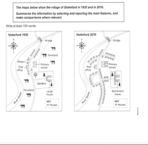
The image displays two maps of Stokeford, contrasting the village layout in 1930 and 2010. The 1930 map includes features such as shops, a post office, primary school, bridge, farmland surrounding most of the village, gardens behind multiple houses, and a large house standing separate. The main road branches from a central point leading towards the bridge in a roughly northward direction. Notably labeled are "KEY Houses" and "HS". The 2010 map shows a more developed road arrangement in a loop format with a central road still leading towards the bridge, marking notable changes in infrastructure and land use. In this map, a retirement home appears near the primary school, the shops and post office remain albeit slightly repositioned, and the farmland has been significantly reduced. Both the houses and gardens appear more uniformly organized in the latter map. The label "KEY Houses" and "HS" are used similarly in both maps, suggesting a continuity in some residential placements or key structures.
Given the complexity of the image, the above description may not be entirely accurate.
Skyrocket your IELTS band score by 1-2 points in under a month with our premium plan!
Note: Both the topic and the answer were created by one of our users.
The maps illustrates the changes which took place in town of Stokeford between 1930 and 2010. Overall, a comparison of two maps reveals an enormous transformation from rural to urban area.
In 1930, the town is located along Stroke river, more precisely, to the east of this. Significant part of town was used for livestock farming and insignificant part was built up with houses. Infrastructure, which mainly consisted of few residental buildings as shops and post offices, was undeveloped. Pedestranisation of town had only one main road which continued from the bridge to the village. To the east of the road, primary school and large house surrounded with garden was established.
The town became more urbanized in less than a century. By 2010, the farmland area was completely replaced by a residental. The new branches emerged from main road, surrounded by newly built residental houses. The primary school, which was located to the east of road, had transformation in size, by extension of additional two blocks. The garden below the school was completely chopped of and also replaced by new accomodation, while the large house next to it was transformed into a retirement home, by extension with two blocks from each side. However, only the bridge and the post office were remained, without any changes.
Word Count: 215
