Our system will evaluate the answer based on this AI-generated description.
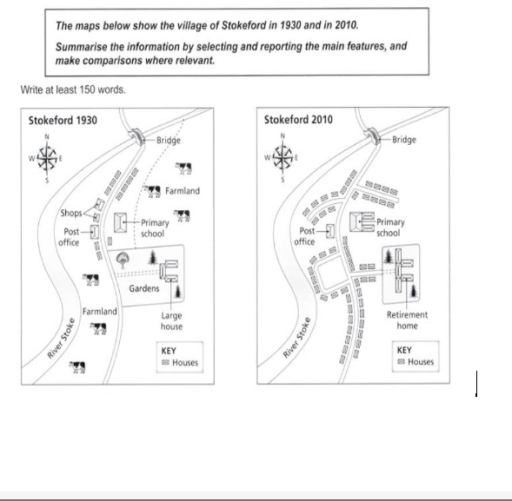
The image displays two maps of Stokeford, contrasting the village layout in 1930 and 2010. The 1930 map includes features such as shops, a post office, primary school, bridge, farmland surrounding most of the village, gardens behind multiple houses, and a large house standing separate. The main road branches from a central point leading towards the bridge in a roughly northward direction. Notably labeled are "KEY Houses" and "HS". The 2010 map shows a more developed road arrangement in a loop format with a central road still leading towards the bridge, marking notable changes in infrastructure and land use. In this map, a retirement home appears near the primary school, the shops and post office remain albeit slightly repositioned, and the farmland has been significantly reduced. Both the houses and gardens appear more uniformly organized in the latter map. The label "KEY Houses" and "HS" are used similarly in both maps, suggesting a continuity in some residential placements or key structures.
Given the complexity of the image, the above description may not be entirely accurate.
Skyrocket your IELTS band score by 1-2 points in under a month with our premium plan!
Note: Both the topic and the answer were created by one of our users.
The two maps illustrate how the village of Stokeford changed over an 80-year period from 1930 to 2010.
Overall, the village underwent significant redevelopment, with many original features being removed or replaced. More residential and recreational facilities were added, including retirement homes and new housing, while the post office and the bridge remained unchanged.
In 1930, there were shops to the north-west of the village, which had been replaced by houses by 2010. The large house and its garden that stood in the centre were demolished and replaced with a retirement home. The farmlands that occupied the east and south of the village disappeared completely.
On the eastern side, the area previously occupied by farmland was taken over by new housing estates. The primary school building was also extended, and new pathways were added for the residents.
Word Count: 137
