Our system will evaluate the answer based on this AI-generated description.
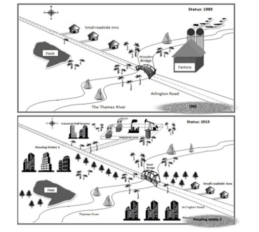
The image displays two comparative diagrams showing the status of an area in 1985 and 2015. In 1985, the area has "Small roadside inns", a singular factory labeled "Factory", a "Wooden Bridge" over "The Thames River", "Arlington Road" curving around a sizeable irregular "Field", and a train track with three train cars running parallel to the river. The 2015 diagram depicts "Housing Estate 1" to the left of Arlington Road, now spanning the river with a "Steel Bridge", a reduced "Field" size, and "Housing estate 2" opposite the field. Additionally, there are palm trees scattered, a new railway station with two platforms and four train cars, and the train track now has an underpass for Arlington Road. The factory from 1985 is replaced with "International Business Center", the road has lamp posts, and the number of small roadside inns has decreased from three to two.
Given the complexity of the image, the above description may not be entirely accurate.
Skyrocket your IELTS band score by 1-2 points in under a month with our premium plan!
Note: Both the topic and the answer were created by one of our users.
These maps compare the differences in the local industrial village of Stamdorf in three decades.
Overall, a huge transformation has taken place in the village (The village has developed to a well-planned town with a massive transformation taken place over this period) and many new facilities have been added.
There weren’t many buildings in 1985 except for small roadside inns and a factory whereas in 2015, there were a large number of buildings like the housing estate 1 and 2, the industrial zone and the industrial staff quarter. The roadside inns on the left side of the Thames river were shifted to the right side of the river, in the south-east corner.
There was a wooden bridge built across the Thames river connecting both sides of the Arlington Road which was later replaced by a steel bridge. The field was further relocated to the south-west corner. The factory built-in 1985 was demolished and an industrial zone was assembled on the north side of the ride in 2015. Surprisingly, despite all the demolitions and changes, the plantations have increased in 2015 from 1985.
Word Count: 182
