🔥 Today Only: Save 30% on Premium — Offer Ends Soon! - Upgrade Now!
Map

Band 7+: The maps show the layout of a beachfront in Australia in 1950 and its current design.

Image for topic: The maps show the layout of a beachfront in Australia in 1950 and its current design.
Our system will evaluate the answer based on this AI-generated description.
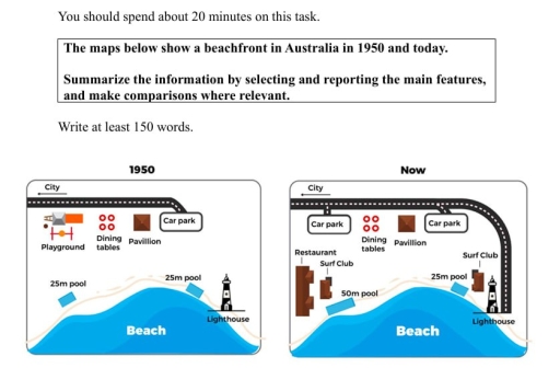
The image displays two maps comparing a beachfront in Australia from 1950 to the present. In 1950, the map shows a city at the top border, followed by a road leading to a car park on the right side. Below the car park are three dining tables aligned vertically, next to which is a pavilion. On the left side of the dining tables, there is a playground. Below the playground, running parallel to the beach, is a 25m pool adjacent to the beach area, which also features a lighthouse at the bottom right corner. In the contemporary map, the city remains at the top, and the road leads to two separate car parks, one near the city and another adjacent to the beach on the right. Centrally, three dining tables are aligned between a restaurant on the left and the unchanged pavilion on the right. Below, a 50m pool stretches parallel to the beach, and a surf club is positioned between the pool and the lighthouse.
Given the complexity of the image, the above description may not be entirely accurate.
Note: Both the topic and the answer were created by one of our users.

The given chart illustrates the alterations of a particular beachfront area, located in Australia, between 1950 and the present time.

Overall, while some facilities, such as the Lighthouse, pavilion and dining area, remained unchanged, all others experienced significant changes. In addition to this, new facilities have been added over the period.

To begin with, a road has been extended to reach the lighthouse. Additionally, there was only one car park at the end of the road in 1950, after decades, another park was placed at the exit of the road into the city, where was previously occupied by playground. Between twin car parks, the pavilion and dining tables were located. There were two identical swimming pools along the beach; however, one of them, which was far away from the lighthouse, had been expanded. Regarding new facilities, two surf clubs have been constructed on two different sides of this place. Moreover, a huge restaurant has been built next to the biggest pool.

Word Count: 161

Answers On The Same Topic:

The maps show the layout of a beachfront in Australia in 1950 and its current design.

The diagrams illustrate the development of the beachfront in Australia between 1950 and the present day. Overall, the beachfront has changed over the period. In particular, new facilities were built to serve tourists, while one recreational feature was removed. In terms of new additions, a new restaurant and two new surf clubs were built. One […]

The maps show the layout of a beachfront in Australia in 1950 and its current design.

Overall, the beachfront underwent extensive modernization, shifting from a quiet, natural layout into a highly developed recreational zone. In 1950, the western part of the beachfront was occupied by a playground, with four dining tables positioned immediately to its east. In the central part, there was a small pavilion. A car park was located on […]

The maps show the layout of a beachfront in Australia in 1950 and its current design.

The maps illustrate how a coastline area in Australia has changed since 1950. Overall, the area became more accessible and recreational at the cost of parking zones, surf clubs, and restaurants. Notably, there is an opportunity for citizens who are car drivers. In 1950, a road leading out of the city ran along the top […]

The maps show the layout of a beachfront in Australia in 1950 and its current design.

The two maps illustrate the transformations that have taken place in an Australian beachfront area from 1950 to the present day. Overall, the site has undergone significant development, shifting from a simple recreational spot to a more modernized coastal area. While some original structures like the lighthouse and pavilion remain, the transportation infrastructure has been […]

The maps show the layout of a beachfront in Australia in 1950 and its current design.

The two maps illustrate the difference of the beachfront’s layout in Australia from 1950 to today. Overall, the beach is located to the south of the map surrounded by two pools and a lighthouse. On the northern side, there is a road adjacent to the car park, and leads west toward the city. Since 1950, […]

See All

Other Topics:

The maps below show the changes that have taken place at the waterfront area of a town called Darwin between 2009 and 2014.

The provided maps depict the transformation of Darwin’s waterfront area between 2009 and 2014. A perusal of the maps reveals significant redevelopment, particularly in the southern section, while the northern part experienced more localized changes. Overall, the waterfront evolved from a more industrialised zone to one with enhanced recreational and educational facilities. In the northern […]

the diagram below shows the plans for designing a trade sho floor from 2009 to 2010

The diagrams compare the layout of a trade show floor in 2009 with a revised version planned for 2010, highlighting changes in the size and position of various facilities. Overall, the most striking change is the reallocation of space between the exhibition area and the conference hall: the former has expanded considerably, while the latter […]

The diagram below shows the changes of the town named Shakefield from 1995 until now. Summarise the information by selecting and reporting the main features, and make comparison where relevant.

The two maps illustrate the changes made to the town of Shakefield from 1995 to the present. Overall, the site has been completely redeveloped since 1995, shifting from a small coastal settlement with farmland and fishing facilities to a more developed residential and tourist area with new accommodation and infrastructure. In 1995, Shakefield was a […]

The diagram shows Lakeside development between years 2000 and 2009.

The two given maps illustrate modifications of the Lakeside area between 2000 and 2009. Overall, this area underwent extensive redevelopments, with commercial, educational and office facilities being constructed. Notably, the natural landscape was reduced in size to make way for an expansion of the industrial complex and there was a clear separation between this complex […]

The maps below show the centre of a small town called Islip as it is now, and plans for is development.

The given two maps illustrates the present area of Islip town centre and how it is expected to develop. Overall, the place is expected to have a significant transformation from residential to some addition of shopping centre and new housing. In the first map, to the north side shops is located while the main road […]

The map below shows three possible locations for a leisure centre. Summarize the information by selecting and reporting the main features and make comparisons where relevant.

The map illustrates three prospective sites for the establishment of a leisure centre in a particular area. Overall, none of site is appropriate for the whole area, but residential area would probably offer much advantages for residents. The first suggested location (A) is an industrial centre, which several factories is situated in there. Although the […]

See All
We have detected unusual activity on your device.
Please verify your identity to continue.
Note: This verification step won't sign you in. If you have a premium account, please log in to access the service as usual.
Google/Gmail Verification
Or verify using Email/Code
We've sent a verification code to:
youremail@gmail.com (Not your email?)
Enter it below to complete the verification process.
Ensure your email address is correct, your inbox is not full, and you check your spam folder. If no email arrives, consider using an alternative email.
You will need a Premium plan to perform your action!
Note: If you already have a premium account, please log in to access our services as usual.

Plans & Pricing

Our mission is to make quality education accessible for everyone.
However, to keep our hardworking team running and this service alive, we genuinely need your support!
By opting for a premium plan, not only do you sustain us in achieving the mission, but you also unlock advanced features to enrich your learning experience.

Free

For learners who aren't pressed for time

What's included on Free
100+ Cambridge IELTS Tests
Instant IELTS Writing Task 1 & 2 Evaluation (2 times/month)
Instant IELTS Speaking Part 1, 2, & 3 Evaluation (2 times/month)
Instant IELTS Writing Task 1 & 2 Essay Generator (2 times/month)
500+ Dictation & Shadowing Exercises
100+ Pronunciation Exercises
Flashcards
Other Advanced Tools

Premium

For those serious about advancing their English proficiency, and for IELTS candidates aspiring to boost their band score by 1-2 points (especially in writing & speaking) in just 30 days or less

What's included on Premium
Save Your IELTS Test Progress & Analyze Mistakes By Question Type
Save Your Own Flashcard Sets & Use Them On Any Device
Unlock All Courses, IELTS Tests, Section & Part Practice
Unlimited AI Conversations
Unlimited AI Writing Enhancement Exercises
Unlimited IELTS Writing Task 1 & 2 Evaluation
Unlimited IELTS Speaking Part 1, 2, & 3 Evaluation
Checked Answers Will Not Be Published
Unlimited IELTS Writing Task 1 & 2 Essay Generator
Unlimited IELTS Speaking Part 1, 2, & 3 Sample Generator
Unlimited Usage Of Advanced Tools & AI Features
Priority Support within 24h (12-month plan only)

Due to the nature of our service and the provided free trials, payments are non-refundable.