🔥 Today Only: Save 30% on Premium — Offer Ends Soon! - Upgrade Now!
Map

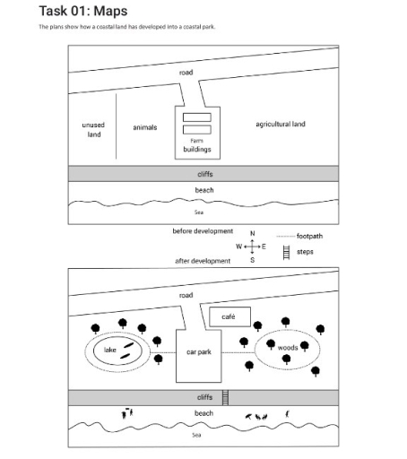
Band 5+: The plans show how a costal land has developed into a coastal park.

Image for topic: The plans show how a costal land has developed into a coastal park.
Our system will evaluate the answer based on this AI-generated description.
The image contains two diagrams depicting the transformation of a coastal land area before and after its development into a coastal park. The top diagram, labeled "before development," shows a delineation featuring segments of agricultural land, a section for farm buildings neighbored by an area for animals, and an unused land portion. This part is bounded by cliffs to the side of the sea, with details of a beach below the cliffs. There are footpath markings running horizontally across the upper portion. The bottom diagram, labeled "after development," illustrates modifications including the addition of a road entering from the upper-left corner, culminating at a car park adjacent to a café. There is a lake situated centrally, surrounded by areas marked as woods with tree symbols. The layout maintains the cliffs and beach adjacent to the sea, preserving their earlier positions. Footpaths now appear to traverse more dynamically throughout the park, featuring steps indicated along the paths by the cliffs.
Given the complexity of the image, the above description may not be entirely accurate.
Note: Both the topic and the answer were created by one of our users.

The diagrams illustrate the changes have taken place in the layout of a coastal land into a coastal park before and after development.

Overall, it is discernible from the plans that the coastal land has seen many significant changes after development, which involve the introduce of several new facilities and

accommodations as well as a way to cross the cliffs.

In the centre of the plans, the fam buildings been replaced by a car park. Similarly, on the west, animals and unused lands has been reconstructed into a lake surrounded by plenty of trees. On the opposite site, the woods has been grown to utilize the agricultural land. Many footpaths from the cark park have been added, leading to its left and right places.

Moreover, some steps have been used for people to climb over the cliffs, showing efforts to make use of the economically potential of the beach. The beach have been a place for tourism with many visitors, serving as a role of profit-making venue.

Word Count: 167

Answers On The Same Topic:

The plans show how a costal land has developed into a coastal park.

The map illustrate how a coastal land has developed into a coastal park. overall view, before coastal park has built, it was main serve for agricultural and rural. But after the coastal park has built have many new facilities main serve for tourism. The coastal land has a main road was lead to the fam […]

The plans show how a costal land has developed into a coastal park.

The maps provide information about the coastal land before and after its development into a coastal park. Overall, the coastal land has been redeveloped with significant alterations, transforming it into a park featuring new recreational facilities such as a car park, a lake, and a café. It is clear that the northern and southern parts […]

The plans show how a costal land has developed into a coastal park.

The plans show the transformation of Coastal Park from Coastal Land. Overall, the area has undergone a number of significant changes, with the introduction of new recreational facilities, such as a new lake and woods, in place of agricultural and unused land. It is also clear that the farm buildings have been removed, and in […]

The plans show how a costal land has developed into a coastal park.

The pictures illustrate changes that have taken place in a coastal area. Overall, this place has undergone a number of changes, the most important of which are the disappearance of land used for agricultural activities in favor of a car parking lot and recreational facilities, and the increasing accessibility of the southern beach, indicating a […]

The plans show how a costal land has developed into a coastal park.

The diagrams depict the transformation of a coastal land into a seaside park in the plan. Overall, the coastal land experiences radical changes, with the most significant being the destruction of two fam buildings and the addition of various infrastructure, along with the renovation of new places, namely, a lake and a woods. One particularly […]

See All

Other Topics:

The two maps illustrate how the layout of a college café has changed from its original design to the present day.

The two maps illustrate how the layout of a college cafe transformed between its original design and the present day. Turning to the southern section of the site, some significant changes can be observed. The grass area with benches, which is not present in the new design, has been converted into an outdoor seating area. […]

The maps below show part of a village in 1910, and the same part of that village in 2010. Summarise the information by selecting and reporting the main features, and make comparisons where relevant. Write at least 150 words.

The diagrams illustrate the transformation of side of a village’s layout from 1910 to 2010. Overall, the village has undergone significant redevelopment. More houses was constructed on the both side of the roads and street, the london road, school road, and high street have remained largely unchanged. In 1910, the village was predominantly dedicated to […]

You should spend about 20 minutes on this task. The maps below show the changes which took place in the resort town of PalmGrove which is 450 kilometers from the nearest city from 1950 to 2000.Summarise the information by selecting and reporting the main features and make comparisons where relevant.

The map illusrates the changes Overall, it can be seen that, the number of hotels have increased drastically over the span of 50 years. In terms of the resort town from 1950 to 1975, the two line road was improved to a four line road which could help with traffic flow. The number of hotels […]

the diagrams below a school library five years ago and now

The maps illustrate how a 5-year redevelopment has shaped a school library during 5 years. Overall, some new facilities have been added, and some rooms have been relocated and removed. Of particular note is that while general structure of school library remains the same, its function appears to have enlarged to include some modern features. […]

Plan A below shows the ground floor of a particular art gallery in 2005. Plan B shows the same area in the present day

The maps illustrate the extent to which the ground floor of a certain art gallery has changed from 2005 to 2026. Overall, the ground floor has gone through major modernization, maintaining its original features while becoming more visitor-friendly and accessible. This transformation involved the introduction of new facilities namely children’s area, temporary exhibitions room and […]

You should spend about 20 minutes on this task. The maps below show the changes which took place in the resort town of PalmGrove which is 450 kilometers from the nearest city from 1950 to 2000.Summarise the information by selecting and reporting the main features and make comparisons where relevant.

The two maps illustrate the development of the resort town of PalmGrove, situated 450 kilometers from the nearest city, over a 50-year period from 1950 to 2000. Overall, PalmGrove underwent significant modernization and expansion over the 50-year period, transforming from a simple coastal area into a fully developed tourist resort with increased hotel accommodations and […]

See All
We have detected unusual activity on your device.
Please verify your identity to continue.
Note: This verification step won't sign you in. If you have a premium account, please log in to access the service as usual.
Google/Gmail Verification
Or verify using Email/Code
We've sent a verification code to:
youremail@gmail.com (Not your email?)
Enter it below to complete the verification process.
Ensure your email address is correct, your inbox is not full, and you check your spam folder. If no email arrives, consider using an alternative email.
You will need a Premium plan to perform your action!
Note: If you already have a premium account, please log in to access our services as usual.

Plans & Pricing

Our mission is to make quality education accessible for everyone.
However, to keep our hardworking team running and this service alive, we genuinely need your support!
By opting for a premium plan, not only do you sustain us in achieving the mission, but you also unlock advanced features to enrich your learning experience.

Free

For learners who aren't pressed for time

What's included on Free
100+ Cambridge IELTS Tests
Instant IELTS Writing Task 1 & 2 Evaluation (2 times/month)
Instant IELTS Speaking Part 1, 2, & 3 Evaluation (2 times/month)
Instant IELTS Writing Task 1 & 2 Essay Generator (2 times/month)
500+ Dictation & Shadowing Exercises
100+ Pronunciation Exercises
Flashcards
Other Advanced Tools

Premium

For those serious about advancing their English proficiency, and for IELTS candidates aspiring to boost their band score by 1-2 points (especially in writing & speaking) in just 30 days or less

What's included on Premium
Save Your IELTS Test Progress & Analyze Mistakes By Question Type
Save Your Own Flashcard Sets & Use Them On Any Device
Unlock All Courses, IELTS Tests, Section & Part Practice
Unlimited AI Conversations
Unlimited AI Writing Enhancement Exercises
Unlimited IELTS Writing Task 1 & 2 Evaluation
Unlimited IELTS Speaking Part 1, 2, & 3 Evaluation
Checked Answers Will Not Be Published
Unlimited IELTS Writing Task 1 & 2 Essay Generator
Unlimited IELTS Speaking Part 1, 2, & 3 Sample Generator
Unlimited Usage Of Advanced Tools & AI Features
Priority Support within 24h (12-month plan only)

Due to the nature of our service and the provided free trials, payments are non-refundable.