Our system will evaluate the answer based on this AI-generated description.
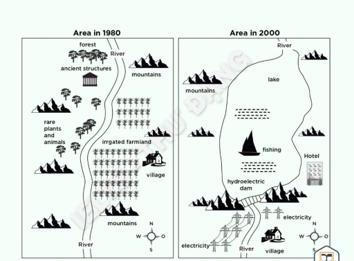
The image displays two comparative maps titled "Area in 1980" and "Area in 2000", each featuring a four-point compass rose (N, S, E, W) in the bottom-right corner. The 1980 map shows a central "River" running north to south; west of the river are "forest" (top), "ancient structures" (temple icon), "rare plants and animals" (trees and wildlife), and scattered "mountains" along the western border; east of the river features "mountains" in the northeast, middle, and southeast, "irrigated farmland" divided into two crop sections, and a "village" southeast of the crops. The 2000 map shows the "River" at the north flowing into a large central "lake" with "fishing" (sailboat icon); a "hydroelectric dam" spans the southern base of the lake between "mountains"; south of the dam, the "River" continues south flanked by power pylons labeled "electricity" on both sides and a relocated "village" to the east; east of the lake is a multistory "Hotel" and "mountains", with additional "mountains" along the western and northeastern perimeters.
Given the complexity of the image, the above description may not be entirely accurate.
Skyrocket your IELTS band score by 1-2 points in under a month with our premium plan!
Note: Both the topic and the answer were created by one of our users.
The given maps provide information about the changes in an area in 1980 and the same area in 2000.
Overall, comparing the two layouts it is evident that the area experienced a significant transformation, the major changes were reducing irrigated farmland and rare plants and animals. while introducing electricity, a lake and a fishing area.
In 1980, there was irrigated farmland, the river and rare plants and animals in the middle of the map, in 2000, these were replaced by a hydroelectric dam and a fishing area. On the northern side of the map there was forest and ancient structures, but in 2000, these were removed.
In addition, in 2000, electricity was incorporated and the village was shifted to the southern part. Moreover, the river on the northern side was connected to a hydroelectric dam. The hotel was included in place of the village on the east side of the map. The mountains had changed slightly from their original positions.
Word Count: 160
