Our system will evaluate the answer based on this AI-generated description.
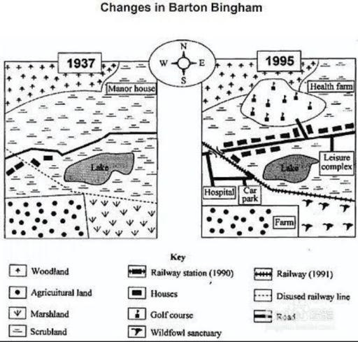
The image shows two maps comparing Barton Bingham in 1937 and 1995. In 1937, elements included a manor house in woodland in the northwest, a railway running west to east through the northern area, agricultural land north and west of the railway, a lake surrounded by marshland in the center, scrubland southeast, and a road running south from the railway station through the scrubland. By 1995, the manor house had become a health farm, the railway had additional lines and disused segments, agricultural areas converted into leisure complex and healthcare facilities including a hospital and car park west of the lake, woodland largely replaced by places like a golf course and minor commercialization, marshland near the lake was removed or diminished, and scrubland converted to a farm. Wildfowl sanctuary introduced in scrubland area, roads and infrastructure expanded connecting new urban elements.
Given the complexity of the image, the above description may not be entirely accurate.
Skyrocket your IELTS band score by 1-2 points in under a month with our premium plan!
Note: Both the topic and the answer were created by one of our users.
The provided maps illustrate the transformation of the Barton Bingham area from 1937 to 1997.
Overall, it is clearly visible that the area of Baton Bingham has developed in terms of various amenities such as, hospital, car park, health farm, railway track and many more.
To commence with, at the centre, there was a lake which remained unchanged, but the land beside that was used to develop a leisure complex. Opposite to the lake, Over the lake there was a road passing from left to right in 1937 which had few homes nearby it, whereas in 1995, numerous homes were built on both the sides of that road. In 1995,the golf course and health farm were made behind the main road by clearing the scrubland and manor house which were there in 1937.
Surprisingly, no change can be found in woodland and agriculture land which were on the top left and bottom left of the corner of the area, but the marsh land located beside the disused rail track in 1937, was converted into wildfowl sanctuary in 1995.In addition, the facility of hospital and car park were added later in 1995 near to the agriculture land .
Word Count: 197