Our system will evaluate the answer based on this AI-generated description.
The image presents two layout maps showing the area of Frenton in 1990 and today, both featuring a north arrow indicator and bisected diagonally from south-southwest to north-northeast by "HIGH STREET". In the 1990 map labeled "Frenton 1990", the area northwest of High Street contains "SCHOOL" at the top-left, "BANK" below it, "TREES" in the bottom-left corner, "LIBRARY" towards the bottom-center, "HOSPITAL" centrally located, and "PLAYING FIELDS WITH TREES" at the top border. Southeast of High Street, features include an irregular central green area labeled "CAFÉ AND PARK", a large vertical rectangular block labeled "HOUSES" along the eastern edge, "THEATRE" at the bottom border, and "SHOPS" at the bottom-right corner. In the second map representing today, northwest of High Street shows "SCHOOL" retained at the top-left, "RESTAURANT" replacing the bank, "TECHNOPARK" replacing the trees, "LIBRARY" retained, an expanded "HOSPITAL", and "BLOCKS OF FLATS" replacing the playing fields. Southeast of High Street, the former houses are replaced by "BLOCKS OF FLATS" alongside a separate "FLATS" block at the top, the central green area is converted to "HOTEL AND GOLF COURSE", the theatre is replaced by "CINEMA", and the shops are replaced by "SUPERMARKET".
Given the complexity of the image, the above description may not be entirely accurate.
Skyrocket your IELTS band score by 1-2 points in under a month with our premium plan!
Note: Both the topic and the answer were created by one of our users.
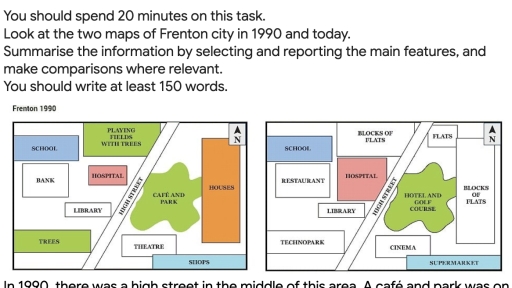
The two diagrams illustrate the changes of Frenton city from 1990 to now.
Overall, it is clear that this area has changed significantly over the period from a basic residential area to a modern and entertaining complex. In particular, many new entertainment amenities like cinema, supermarket, hotel and golf course and flats have been built around the area.
In 1990, there was a high street in the middle of this area. A café and park was on the right of the high street. Next to the café and park, there is a block of houses. A theatre and shops are located on the south side of the houses. On the other side of the highway, there were playing fields with trees on the north side. A school is located on the left corner of this zone. The hospital was surrounded by a bank and a library. A green area with many trees was in the bottom left-hand corner of the city.
Now, there are many changes in this area. On the left side of the highway, the playing fields with trees have been converted to the block of flats. The hospital has now been expanded in the same location. The bank area has now been enlarged and replaced by the restaurant. The green zone has now been redeveloped to the technopark. On the right side of the high street, the café and park has been converted to the hotel and golf course. To the south of this area, the theatre has been changed to the cinema. On the North East corner of the city, two new blocks of flats have been constructed along the right side of the hotel and golf course. On the bottom right-hand corner, the shops have been redeveloped to the supermarket.
Word Count: 295
