🔥 Today Only: Save 30% on Premium — Offer Ends Soon! - Upgrade Now!
Map

Band 5+: The two maps show how a coastal town developed between 1950 and 2007.

Image for topic: The two maps show how a coastal town developed between 1950 and 2007.
Our system will evaluate the answer based on this AI-generated description.
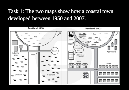
The image presents two comparative layout maps labeled "Pentland: 1950" and "Pentland: 2007", each featuring a northeast-pointing compass arrow. In "Pentland: 1950", a semicircular "Sea" occupies the northern section, bordered by a road network labeled "Roads". The road system comprises a vertical central road with a western branch connecting to an "Industrial area" containing three rectangular building blocks, and an eastern branch terminating at a circular "Car park". Extensive areas labeled "Grassland" occupy the southwest and southeast quadrants. In "Pentland: 2007", the semicircular northern "Sea" includes a "Marina" with boat slips and five vessels (a large cruise ship, motorboats, and a sailboat). Northwest of the coastal road is a "Park" with two trees, connected to a "Swimming pool", adjacent to a gridded "Multi-storey car park". Below this are three large storefronts labeled "Shops", and across an east-west "Roads" segment to the south sits a "Cinema". Northeast of the central road is a cluster of five multi-story buildings labeled "Apartments", positioned above a row of six smaller "Shops". South of the eastern road junction are two cul-de-sac streets accommodating ten residential houses (five per row).
Given the complexity of the image, the above description may not be entirely accurate.
Note: Both the topic and the answer were created by one of our users.

The maps illustrate the development of a coastal town between 1950 and 2007.

Overall, the city had undergone some changes, with the elimination of the grassland. Meanwhile, the town has become more modern, with the addition of several new facilities and the expansion of the road.

About the Car park and the East Grassland, there were many different changes over the years. Before the redevelopment, the car park and the grassland were situated, which has changed to the Industrial area and Shops on the East side of the map, while the car park had been replaced to the Apartments over the years. In the centre part of the map, the Roads had been expanded in 2007, which was wider and larger at that time.

Regarding the Industrial area and the remaining grassland, the west grassland had been replaced by the cinema, with the addition of the road and the bigger shops. The Industrial area was replaced by many public amenities, which was constructed by the Multi-economy car park, the swimming pool and the Park. Meanwhile, there was a sea in 1950, which was replaced by the Marina later, and surrounded by the road in 2007, respectively.

Word Count: 196

Other Topics:

The maps showed the changes in a city centre from the year 2000 to the present day. Summarise the information by selecting and reporting the main features, and make comparisons where relevant.

The given map demonstrates the transformation of a city centre from 2000 to the present. Overall, there have been some major changes and the city has become more urbanized and more convenient. Furthermore, the striking changes include the new recreational and public facilities, and the elimination of green spaces. In the initial map, the northern […]

The maps below show Pebbleton 20 years ago and today

The map illustrates that development which took place in the town Pebbleton over the last twenty years.Overall, it is evident that Pebbleton has undergone many significant changes, old fort has been turned into children ‘s playground, film studio has been converted into flats and footpath is added flats and tennis courts. Twenty years ago, it […]

The maps below show the changes experienced by the town of East Haven at the beginning of the 21st Century. Summarise the information by selecting and reporting the main features, and make comparisons where relevant.

The maps illustrate the town of East Haven has experienced the changes between the years of 2008 and 2016. Overall, it is clear that the entire town has met a significant development by constructing numerous buildings and adding new areas. The old town which was located in the north of the map, was domolished to […]

The maps below show the current and future plans for a town centre. Summarise the information by selecting and reporting the main features, and make comparisons where relevant

The maps demonstrate the now and future plans for a town centre. Overall, the current plan have a lot of car parks, which in the future, will be replaced of underground ones. Council offices will relocate to place where was exhibition, while the exhibition will be more smaller than now. The cinema and a shopping […]

The maps below show changes in the city of Nelson in recent times. Summarise the information by selecting and reporting the main features, and make comparisons where relevant. Write at least 150 words.

The two maps depict the transformations in the city of Nelson from 2000 to the present day. Overall, the city witness modernizations, characterized by the rebuild of new train station and new covered market. Highlighting new shopping center, restaurants, and bars and clubs. In 2000, there was green area in the northeast corner of the […]

The map illustrates the evolution of the Lakeside area from 2000 to 2009

The given map depicts modifications that happened in the Lakeside area between 2000 and 2009. It can be seen that a sustainable number of changes have taken place during the given period. In 2000, there was a colossal zone of wood land that extended from northeast to southeast. The lake was placed in the northeast […]

See All
We have detected unusual activity on your device.
Please verify your identity to continue.
Note: This verification step won't sign you in. If you have a premium account, please log in to access the service as usual.
Google/Gmail Verification
Or verify using Email/Code
We've sent a verification code to:
youremail@gmail.com (Not your email?)
Enter it below to complete the verification process.
Ensure your email address is correct, your inbox is not full, and you check your spam folder. If no email arrives, consider using an alternative email.
You will need a Premium plan to perform your action!
Note: If you already have a premium account, please log in to access our services as usual.

Plans & Pricing

Our mission is to make quality education accessible for everyone.
However, to keep our hardworking team running and this service alive, we genuinely need your support!
By opting for a premium plan, not only do you sustain us in achieving the mission, but you also unlock advanced features to enrich your learning experience.

Free

For learners who aren't pressed for time

What's included on Free
100+ Cambridge IELTS Tests
Instant IELTS Writing Task 1 & 2 Evaluation (2 times/month)
Instant IELTS Speaking Part 1, 2, & 3 Evaluation (2 times/month)
Instant IELTS Writing Task 1 & 2 Essay Generator (2 times/month)
500+ Dictation & Shadowing Exercises
100+ Pronunciation Exercises
Flashcards
Other Advanced Tools

Premium

For those serious about advancing their English proficiency, and for IELTS candidates aspiring to boost their band score by 1-2 points (especially in writing & speaking) in just 30 days or less

What's included on Premium
Save Your IELTS Test Progress & Analyze Mistakes By Question Type
Save Your Own Flashcard Sets & Use Them On Any Device
Unlock All Courses, IELTS Tests, Section & Part Practice
Unlimited AI Conversations
Unlimited AI Writing Enhancement Exercises
Unlimited IELTS Writing Task 1 & 2 Evaluation
Unlimited IELTS Speaking Part 1, 2, & 3 Evaluation
Checked Answers Will Not Be Published
Unlimited IELTS Writing Task 1 & 2 Essay Generator
Unlimited IELTS Speaking Part 1, 2, & 3 Sample Generator
Unlimited Usage Of Advanced Tools & AI Features
Priority Support within 24h (12-month plan only)

Due to the nature of our service and the provided free trials, payments are non-refundable.