Our system will evaluate the answer based on this AI-generated description.
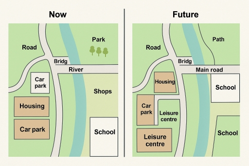
The image shows two maps labeled "Now" and "Future." In the "Now" section, there is a road running north to south, crossing a river via a bridge on its southern portion; a car park and housing are situated south-west of the bridge, along with another car park; an area labeled 'Park' is located in the north-east quadrant; a 'School' is positioned in south-east quadrant; and adjacent to these is an area marked 'Shops' east of river. In the "Future" section, "Road" remains in the same orientation but from the south transforms into "Main road" that intersects with river via the bridge; "Housing" is relocated to the north-east above "Car park"; "Leisure centre" appears south of car park; the plot marked "School" is enlarged to cover the south-east quadrant alongside another "School" north of the expanded south school, and a "Path" runs parallel to the northeastern segment of river across from both schools.
Given the complexity of the image, the above description may not be entirely accurate.
Skyrocket your IELTS band score by 1-2 points in under a month with our premium plan!
Note: Both the topic and the answer were created by one of our users.
The depicted diagram compares the blueprint of a town at present and its offered future development.
In overview, it is noticeable that the road, bridg and the school remained the same. Nevertheless, in future, another school was suggested to construct as well.
Primarily, in current times, in the lower left side, there are 2 car parks, and housing in the middle of them. Whereas, the plan suggests 2 leisure center, a car park and housing on the top. Secondly, in recent times, there is a school and a shop, in the lower right side. Although, the future plan suggests construction of 2 schools, so the shop shall be removed.
Furthermore, in present time, there is a river and a park on the upper right side of the river, but future plan offers a main road, in the place of river. Also, path for walking in the place of park. On the upper side of the river, there is a bridg and a road by side, which remains the same in the proposed plan.
Word Count: 173
