Our system will evaluate the answer based on this AI-generated description.
The image contains two diagrams, labelled "NOW" and "PROPOSED PLAN," depicting two different layouts of an area with various features. In the "NOW" diagram, there is an Airfield in the top left corner connected to a Roundabout, which is linked to three roads - one towards the Gas station in the bottom left corner, one towards the Town center in the middle right, and one intersecting a Railway with a Bridge above the Railway, leading upwards with 'build-up area' written alongside. A fourth road encircles the Town center marked as 'ring-road'. In the "PROPOSED PLAN" diagram, the layout is slightly altered; the 'Industrial estate' now appears above the Railway in the upper right corner, connected to a modified 'ring-road' with 'build-up area' written along it again. The Gas station has moved towards the bottom right and is positioned on a new road labelled 'A4' extending outside of the diagram's boundary, marked with a dashed line. The Roundabout, Airfield, and Town center remain in similar positions, and 'A2' is written alongside the road between the Roundabout and Industrial estate.
Given the complexity of the image, the above description may not be entirely accurate.
Skyrocket your IELTS band score by 1-2 points in under a month with our premium plan!
Note: Both the topic and the answer were created by one of our users.
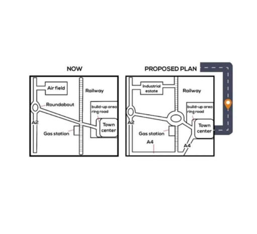
The two maps compare the town centre at present and its planned development in the future.
Overall, the town centre will become significantly more developed, with several new buildings and roads being added, while some existing features will be removed or relocated.
In the current map, there is an airfield located in the west. In the north, there is a roundabout and a gas station. Meanwhile, in the east, there is a railway, a built-up area surrounded by a ring road, and the town centre. A main road runs through the centre of the area. In addition, the A2 road is located next to the gas station.
In the future plan, the airfield will be replaced by an industrial estate, and the roundabout will be removed. The road network will be expanded with the construction of a ring road. The gas station will be relocated slightly to the south. The built-up area and its ring road will be extended further south. Additionally, an A4 road will be constructed at the bottom of the map. While many changes are planned, the railway will remain unchanged.
Word Count: 184