Our system will evaluate the answer based on this AI-generated description.
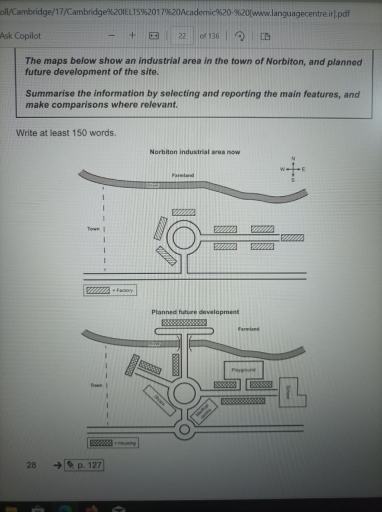
The image displays two schematic maps of an industrial area in the town of Norbiton, illustrating the current layout and a planned future development. The first map, labelled "Norbiton industrial area now," features a rectangular factory at the centre, connected to a railway with a platform to the west and bordered by Farmland to the north. Directly east of the factory, there's a road running north-south with three rectangular depots along it. The second map, titled "Planned future development," shows the factory and the existing road with depots. Additions in the future plan include a roundabout south of the factory, an extended platform along the railway, and more structured parking adjacent to the platform. The road extends south in the future plan, connecting to another road that runs east-west, with another roundabout on this junction. Farmland still borders the area to the north but is also planned to the northeast and east of the facility, suggesting potential expansion or preservation of green spaces.
Given the complexity of the image, the above description may not be entirely accurate.
Skyrocket your IELTS band score by 1-2 points in under a month with our premium plan!
Note: Both the topic and the answer were created by one of our users.
The two maps of Norbiton’s urban layout highlight a dramatic transformation, with the current design depicting an industrial area, while its proposed redevelopment reflects a shift towards a residential district. Major changes are anticipated, including the introduction of a children’s playground, an academic institution, retail outlets, and a public health institution.
Factories are a central part of the current urban landscape, with several production sites surrounding a circular road. In contrast, the projected plan involves demolishing these industrial buildings and replacing them with residential areas. Additionally, the establishment of an educational institution, an entertainment area, a public health centre, and convenience stores is designed to provide residents with convenient access to local amenities.
To facilitate access to community infrastructures, interconnected roads will be constructed to connect residential complex to these newly developed amenities. Furthermore, northern farmland will relocated to the east while it actual location will be replaced by a cluster area near the stream.
Word Count: 155