Our system will evaluate the answer based on this AI-generated description.
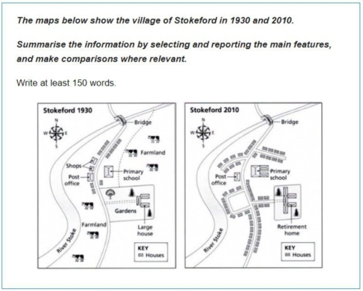
The image displays two maps of the village of Stokeford, one from 1930 and another from 2010, each with a key indicating Houses and Shops. The 1930 map features a river on the left, leading to a bridge in the upper right, with a road crossing the bridge and curving down through the village, passing by shops, a post office, primary school, and farmland before ending in a 'T' intersection. A large house lies below the 'T' intersection, surrounded by gardens. The 2010 map shows the river and bridge in the same location, but the road now bypasses the primary school and post office, which are situated next to each other and a new retirement home replaces the large house and gardens. The shops no longer exist, and additional houses line the road leading to the post office and primary school. The farmland has been subdivided into lots for houses.
Given the complexity of the image, the above description may not be entirely accurate.
Skyrocket your IELTS band score by 1-2 points in under a month with our premium plan!
Note: Both the topic and the answer were created by one of our users.
The picture illustrates the changes made to the layout of Stokeford from 1930 to 2010. In general, the northern and the western areas of Stokeford remained untouched, while significant changes in accommodation were observed in other areas.
The bridge remained unchanged in 2010 compared to its appearance in 1930. However, significant changes can be noted in the surrounding areas. To the southeast of the bridge, farmland was cleared to build two rows of houses, and a new road was constructed between these rows. Moving west, the shops were replaced to accommodate additional housing. On the south side of the houses on the eastern side, the primary school was expanded.
Further southeast of the primary school, the large house was converted into a retirement home, which underwent extension, leading to a reduction in the size of the surrounding garden area. Finally, in the southern area next to the River Stoke, more farmland was cleared to meet the housing demand.
Word Count: 158
