Our system will evaluate the answer based on this AI-generated description.
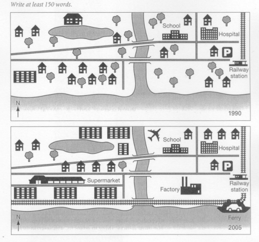
The image depicts two illustrated maps labeled with the years 1990 and 2005, showing changes in a location's infrastructure over time. In the 1990 map, the layout includes a railway station at the extreme right, a hospital and a school situated near each other at the center, and a parking area on the left side. The structures are surrounded by a substantial number of trees and residential houses. A road runs horizontally through the center of the map with one bridge crossing over a body of water. The compass on the map indicates North is towards the upper left corner. In the 2005 map, several changes are noted, including the addition of a supermarket next to the hospital, a factory located on the lower side of the railway station, and a ferry terminal at the far right. The school maintains its position, but the parking area has been relocated to a spot between the supermarket and the hospital. The number of residential houses appears reduced, and the natural scenery has been diminished, with fewer trees shown. The central road appears wider with two bridge crossings, and the compass indicates North in the same direction as in the 1990 map.
Given the complexity of the image, the above description may not be entirely accurate.
Skyrocket your IELTS band score by 1-2 points in under a month with our premium plan!
Note: Both the topic and the answer were created by one of our users.
The maps illustrate the transformation of the seaside resort of Templeton between 1990 and 2005.
Overall, Templeton underwent significant urban development over the 15-year period, changing from a quiet residential area into a more industrialized and commercialized town. New facilities such as a supermarket, a factory, and an airport were introduced, while several green areas and houses were removed to make way for these developments.
In 1990, Templeton was a relatively small town characterized mainly by residential housing. A number of houses were located on both sides of the river, and public services – including a school, a hospital, a parking lot, and a railway station – were concentrated in the eastern part of the area. The western side, by contrast, contained mostly houses and green spaces, with a small lake situated near the center.
By 2005, the town had expanded considerably. A large supermarket was constructed to the south of the river, replacing several houses, and a factory was established nearby along the railway line. In addition, a ferry terminal was introduced in the southwest corner, providing a new means of transport. The most noticeable change was the construction of an airport to the north of the river, reflecting Templeton’s growing modernization and connectivity. However, these developments came at the cost of natural areas, as many trees and open spaces disappeared.
Word Count: 222