Our system will evaluate the answer based on this AI-generated description.
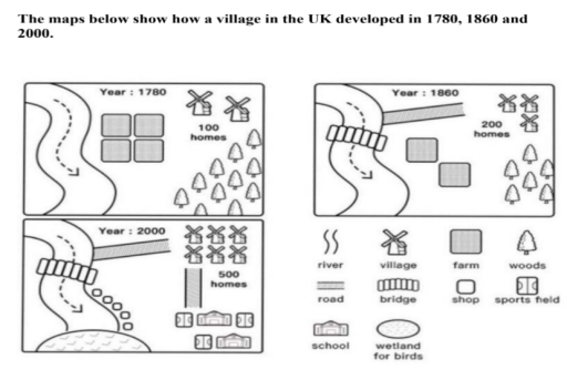
The image displays three developmental stages of a UK village in maps labeled 1780, 1860, and 2000. Year 1780 depicts a river flowing west to east, intersected near its midpoint by a bridge leading to a cluster of four village squares representing 100 homes southeast of the river, adjacent to a collection of eight trees denoting woods with nearby five squares illustrating farms. By 1860, the village expands to encompass seven village squares representing 200 homes positioned more northwest of the river, retaining four farms and expanding the woods to twelve trees. In 2000, the village showcases a substantial expansion to 500 homes indicated by twenty-five village squares, situated directly north of the river, incorporates one shop, one school, and two sports fields to the northeast, while the woods maintain an arrangement of six trees; farms diminish in presence as additional features include a wetland for birds located southeast.
Given the complexity of the image, the above description may not be entirely accurate.
Skyrocket your IELTS band score by 1-2 points in under a month with our premium plan!
Note: Both the topic and the answer were created by one of our users.
The three maps showing steady development of the UK outskirts and the way it was filled through the centuries.
To commence with, in the 18th centure on the riverside territory there were only four farms between three small villages and a forest. Notiable seen than river havent been used in the first centure, however, in 1860 the road and bridge were constructed. Besides these infrastructure details, people have build 5 shopping buildings alongside the river. Likewise all farms were deconstracted in this neighborhood.
In addition, two villages whhich were situated in the north east have risen. Initially there was a gradual increase in number of villages in 19th century, however, in 2000 population of this area increased in geometrical progression, 9 villages, respectfully. Moreover, new schools and cport fields appeared at the last decade which lead to addition of the new road from the north-east ot the south-east where there are located now. Such rocket expansion of the infrastructure cut of the forest which covered almost half of the neighborhood in 1780.
Word Count: 172
