Our system will evaluate the answer based on this AI-generated description.
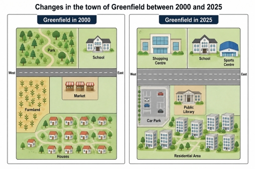
The image presents two town layout maps titled "Changes in the town of Greenfield between 2000 and 2025", showing "Greenfield in 2000" on the left and "Greenfield in 2025" on the right, both divided horizontally by a West-to-East main road. In 2000, north of the road contains a "Park" on the west with a winding pathway and trees, and a "School" building on the east; south of the road features "Farmland" in the southwest, a "Market" with three stall canopies in the central area, and a residential zone labeled "Houses" comprising 13 single-family houses and green spaces across the southeast. In 2025, the road is widened, and north of the road consists of a "Shopping Centre" in the northwest and a "School" alongside an added "Sports Centre" in the northeast; south of the road contains a "Car Park" with parking bays in the southwest, a "Public Library" in the central area, and an expanded "Residential Area" containing six multi-story apartment buildings across the southeast.
Given the complexity of the image, the above description may not be entirely accurate.
Skyrocket your IELTS band score by 1-2 points in under a month with our premium plan!
Note: Both the topic and the answer were created by one of our users.
The maps compare how the layout of Greenfield’s town changed over a 25-year period from 2000 to 2025.
Overall, Greenfield’s town experienced a significant shift, particularly the construction of new facilities and the expanding of roads. Although the school remained unchanged, many high buildings were built to meet the resident’s demands.
Looking first at the year 2000, a road ran through from west to east, reparated into two distinct areas. On the northern side of the town, a park was located in the left-hand side corner, while a school was positioned on the other hand. There was a row of houses occupying the southern edge, with its surrounding tree-filled areas. To the west of this map a farmland section lies there, whereas a market was located on the southern side of the road.
Following 25 years, the former road was expanded by three lanes, despite it remained unchanged. The park was broken down to make way for a new shopping centre, which was located on the left-hand side corner. Although the school stayed at its initial position, a sports centre was established adjacent to it. A row of houses and farmland were replaced by a row of high buildings and a car park. A market, which was located on the remaining space, was converted into a public library.
Word Count: 218
